Malheur National Wildlife Refuge
| Malheur National Wildlife Refuge | |
| Protected Area | |
 Refuge headquarters | |
| Country | United States |
|---|---|
| State | Oregon |
| Region | Harney County |
| City | 30 miles (48 km) south of Burns |
| River | Donner und Blitzen River |
| Location | Harney Basin |
| - elevation | 4,121 ft (1,256 m) |
| - coordinates | 43°15′57″N 118°50′39″W / 43.26583°N 118.84417°WCoordinates: 43°15′57″N 118°50′39″W / 43.26583°N 118.84417°W [1] |
| Founded | in 1908 |
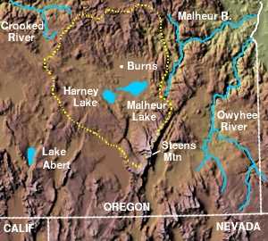
 Harney Basin and surrounding area
| |
|
Location of the refuge in Oregon
| |
Malheur National Wildlife Refuge is located roughly 30 miles (48 km) south of the town of Burns, Oregon. The refuge area is roughly T shaped with the southernmost base at Frenchglen, the left top at Malheur Lake and the right top at Harney Lake.
Named for an early pioneer, the refuge is a hotspot for birding, fishing and hiking.
Wildlife
Numerous wildlife occurs in the area, with as many as 320 species of birds and 58 species of mammals found in the refuge. A large number of birds and mammals can be found amongst the deserts, grasslands, marshes and rimrock. Malheur serves as a Pacific Flyway stop for the Northern Pintail and Tundra Swan, Lesser and Greater Sandhill Crane, Snow Goose and Ross’ Goose. Ducks, grebes, pelicans and trumpeter swans are drawn to the numerous ponds, marshes and lakes. Deer, antelopes, ducks, pheasants, thrashers and quails can be found in the upland areas amongst the sagebrush, greasewood and wild rye.[2]
Geography
The Donner und Blitzen River flows northward through the middle of the refuge, and is irrigated out to create a large artificial wetland, where once a natural wetland stood. The Donner und Blitzen River flows into Malheur Lake, which flows into Harney Lake forming a large salt sea (Harney Basin). This open water brings thousands of migrating birds through the wildlife refuge every year. Along with the extensive marshland, the total size is 187,000 acres (757 km2). Exceptionally hot in the summer, and cold in the winter, the late spring and early fall are popular times to visit this desert oasis.
In addition to being one of the most extensive freshwater marsh ecosystems in the western United States, Malheur NWR has sometimes generated controversy about land management practices.[3]
References
- ↑ "Malheur National Wildlife Refuge". Geographic Names Information System (GNIS). United States Geological Survey. November 28, 1980. Retrieved August 15, 2009.
- ↑ "Malheur National Wildlife Refuge". U.S. Fish and Wildlife Service. Retrieved August 11, 2009.
- ↑ Durbin, Kathie (October 3, 1994). "Ranchers arrested at wildlife refuge". High Country News. Retrieved August 15, 2009.
External links
![]() Media related to Malheur National Wildlife Refuge at Wikimedia Commons
Media related to Malheur National Wildlife Refuge at Wikimedia Commons