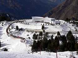
Malam Jabba
Malam Jabba (also Maalam Jabba, Urdu: مالم جبہ) is a Hill Station in the Karakoram mountain range nearly 40 km from Saidu Sharif in Swat Valley, Khyber Pakhtunkhwa, Pakistan. It is 314 km from Islamabad and 51 km from Saidu Sharif Airport.
Malam Jabba is home to the only ski resort in Pakistan.[1] The area also contains two Buddhist stupas and six monasteries that are scattered around the resort. The presence of the monuments at such a height indicates that the area has been inhabited for over 2000 years.
Two trekking trails are located near the Malam Jabba resort. The first passes through the Ghorband Valley and Shangla Top and starts about 18 km from the resort. The other trail passes through the Sabonev Valley and is about 17 km from the resort.
Malam Jabba ski resort

The Malam Jabba Ski Resort, owned by the Pakistani Tourism Development Corporation, had a ski slope of about 800 m with the highest point of the slope 2804 m (9200 ft) above sea level. Malam Jabba Ski Resort was possible due to the joint efforts of the Pakistan government and its Austrian counterpart. The resort was equipped with modern facilities including roller/ice-skating rinks, chair lifts, skiing platforms, telephones and snow clearing equipment.
MOU signing ceremony for developing Malamjabba resort was held on 6 September 2014 in Islamabad. New resort will have 4-star hotel, chairlift, cable car,snow boarding and ski slopes for adventure lovers, national and international tourist.
Resort will be first of its kind in Pakistan with mega facilities for winter sporting and adventure tourism.
.jpg)

See also
- Marghazar - Swat Valley
- Miandam - Swat Valley
- Malam Jabba -Swat Valley
- Madyan - Swat Valley
- Behrain - Swat Valley
- Kalam -Swat Valley
- Utror - Kalam Valley
- Usho - Swat Valley
- Gabral -Kalam Valley
References
- ↑ "Pakistan hosts ski tournament in former Taliban area". BBC. 2011-01-29. Retrieved 2011-01-29.
External links
- - Swat Complete Tour Guide
- Tourism.gov.pk - Malam Jabba
- Photos from Malam Jabba by Waqas Usman (2005)
- Photos and Info by Hanif Bhatti
Coordinates: 34°47′59″N 72°34′18″E / 34.79972°N 72.57167°E