Makin (islands)
 | |
 | |
| Geography | |
|---|---|
| Location | Pacific Ocean |
| Coordinates | 3°23′N 173°00′E / 3.383°N 173.000°E |
| Archipelago | Gilbert Islands |
| Area | 7.89 km2 (3.05 sq mi) |
| Highest elevation | 3 m (10 ft) |
| Country | |
| Demographics | |
| Population | 1,798 (as of 2010 Census) |
| Density | 228 /km2 (591 /sq mi) |
| Ethnic groups | I-Kiribati 100% |
Makin is the name of a chain of islands located in the Pacific Ocean island nation of Kiribati. Makin is the northernmost of the Gilbert Islands, with a population (in 2010) of 1,798.[1]
Geography
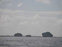
Makin is located six km northeast of the northeastern corner of Butaritari atoll reef and 6.9 km from the Butaritari islet of Namoka. It is a linear reef feature, 12.3 km long north-south, with five islets, the two larger ones being inhabited (Makin and Kiebu). The third largest, and southernmost islet, Onne, is also inhabitable. This string of islands is the northernmost feature of the Gilbert Islands, and the third most northerly in the island nation of Kiribati (only Teraina and Tabuaeran of the Line Islands are more northerly). Makin is not a true atoll, but since the largest and northernmost of the islets, also called Makin, has a nearly landlocked lagoon, 0.3 km² in size and connected to the open sea in the east only through a 15 metre wide channel (with a road bridge over it), it might be considered a degenerate atoll. Kiebu, the second largest islet, has an even smaller, completely landlocked lagoon on its eastern side, with about 80 m in diameter (making an area of about 0.005 km² or 0.5 hectares) and at distance of 60 m to the open sea.[2]
Since neighboring Butaritari was called Makin Atoll by the U.S. military, the feature used to be called Makin Meang (Northern Makin) or Little Makin to distinguish it from the larger atoll. Now that Butaritari has become the preferred name for that larger atoll, speakers tend to drop the qualifier for Makin.
The Gilbert islands are sometimes regarded as the southern continuation of the Marshall Islands, which are NNW of it. The closest island of the Marshall Islands, Nadikdik Atoll, is 290 km NNW of Makin.
Makin has a land area of 6.7 km² and a population of 1,798 (census of 2010[1]).
Islets and Villages
Makin island consists of five small islets. Of these, only Makin and Kiebu islands are permanently inhabited. The total population of Makin is 1,798.
| Makin: Population and Land Area | ||||
| Islet/Village | Population 2010[1] | Land area (usable)[1] | Density | Area not available for use[1] |
|---|---|---|---|---|
| Little Makin | 1,364 | 1,541.5 acres (624 ha) | 0.9 people per acre | Enclosed lagoon 84.7 acres |
| Bikin Eitei | 8 acres (3 ha) | |||
| Aonibike | 30.9 acres (13 ha) | |||
| Tebua Tarawa | 5 acres (2 ha) | |||
| Kiebu | 434 | 242.2 acres (98 ha) | 1.8 people per acre | |
| Onne | 122.6 acres (50 ha) | |||
| Makin Total | 1,798 | 1,950.2 acres (789 ha) | 0.9 people per acre | Enclosed lagoon 84.7 acres |
Climate
The climate is very similar to neighboring Butaritari atoll, with lush vegetation and high rainfall. Typical annual rainfall is about 4 m, compared with about 2 m on Tarawa Atoll and 1 m in the far south of Kiribati. Rainfall on Makin is enhanced during an El Niño.[2]
Economy
Makin, like other Kiribati islands, has a mainly subsistence economy. Most houses are made from local materials, and most households rely on fish, coconut and fruit (particularly banana and papaya) as the mainstay of their diet, though imported rice, sugar and tobacco are also seen as necessities. Makin is a high producer of copra, but has few other economic activities apart from a limited number of Government and Island Council jobs. Many families receive remittances from relatives working on South Tarawa or overseas.[3]
History
In 1606 Pedro Fernandes de Queirós sighted Butaritari and Makin, which he named the Buen Viaje (‘good trip’ in Spanish) Islands.[4][5]
Nakaa Beach is located at the northern tip of Makin Atoll is an important site in the traditional mythology of the island group, being the departing point for the spirits of the dead heading to the underworld.
Little Makin Post Office opened around 1925.[6]
Japanese forces occupied the island in December 1941, days after the attack on Pearl Harbor. The United States invaded and captured the island after the Battle of Makin, which lasted from November 20, 1943, to November 24, 1943.
Visiting Makin
Makin Airport, located immediately northeast of Makin Village, between the lagoon and the sea, has ICAO code NGMN and IATA code MTK. It is served by two weekly Air Kiribati flights to Butaritari and to Bonriki International Airport in Tarawa.
There are no tourist facilities on Makin, but both the Kiribati Protestant Church and the Island Council maintain guest houses.[7]
References in Popular Culture
Makin is featured in Call of Duty: World at War, in the first single player level ‘Semper Fi’, and two multi-player map, 'Makin' and 'Makin Day'. It also features as a campaign location in the game Medal of Honor: Pacific Assault as 'Makin Atoll'
See also
References
- ↑ 1.0 1.1 1.2 1.3 1.4 "Kiribati Census Report 2010 Volume 1" (PDF). National Statistics Office, Ministry of Finance and Economic Development, Government of Kiribati. Retrieved 17 March 2013.
- ↑ 2.0 2.1 "1. Makin" (PDF). Office of Te Beretitent - Republic of Kiribati Island Report Series. 2012. Retrieved 28 April 2015.
- ↑ "Makin Island Report". Government of Kiribati.
- ↑ Maude, H.E. (1959). "Spanish Discoveries in the Central Pacific: A Study in Identification". The Journal of the Polynesian Society 68 (4): 284–326.
- ↑ Kelly, Celsus, O.F.M. La Austrialia del Espiritu Santo. The Journal of Fray Martín de Munilla O.F.M. and other documents relating to the Voyage of Pedro Fernández de Quirós to the South Sea (1605-1606) and the Franciscan Missionary Plan (1617-1627) Cambridge, 1966, p.39, 62.
- ↑ Premier Postal History. "Post Office List". Premier Postal Auctions. Retrieved 5 July 2013.
- ↑ "Kiribati Tourism - Outer Islands Accommodation Guide". Government of Kiribati. Retrieved 15 March 2013.
| |||||||||||||||||||||||||||||
Coordinates: 3°23′00″N 173°00′00″E / 3.38333°N 173.00000°E