Major Deegan Expressway
| ||||
|---|---|---|---|---|
| Major William Francis Deegan Expressway | ||||
|
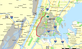
Map of the Bronx in New York City with Major Deegan Expressway highlighted in red | ||||
| Route information | ||||
| Maintained by NYSDOT | ||||
| Length: | 8.38 mi[1] (13.49 km) | |||
| Existed: | April 1939[2] – present | |||
| History: | Completed in 1956[2] | |||
| Major junctions | ||||
| South end: |
| |||
|
| ||||
| North end: |
| |||
| Highway system | ||||
| ||||

The Major Deegan Expressway, officially named the Major William Francis Deegan Expressway and locally known as the Deegan, is a north–south expressway in the New York City borough of the Bronx. It is the southernmost 8.38 miles (13.49 km) of Interstate 87 (I-87), beginning at I-278 at the interchange of the Bruckner Expressway and the Triborough Bridge in the south Bronx and ending at the Westchester County line in Yonkers, where the New York State Thruway begins. In between, the Major Deegan Expressway winds through Van Cortlandt Park, intersects with I-95 (the Cross Bronx Expressway) near the George Washington Bridge, and passes by Yankee Stadium on its eastern flank.
The expressway was completed in 1956 and became part of I-87 when that highway was assigned as part of the creation of the Interstate Highway System in 1957. It is named for William Francis Deegan, who died in 1932. He was an architect, a Major in the Army Corps of Engineers and a Democratic political leader in New York City.
Route description

The Major Deegan Expressway begins at an interchange with the Bruckner Expressway (I-278) in the South Bronx. The route heads northwestward from the junction, loosely paralleling the Harlem River as it carries I-87 through Mott Haven. After 1 mile (1.6 km), the highway makes a turn to the north, mirroring a change in the nearby river's course. It passes by Yankee Stadium on its way to Highbridge, where the Deegan connects to the Cross Bronx Expressway (I-95 and U.S. Route 1 or US 1) at the eastern approach to the Alexander Hamilton Bridge. The Deegan remains in close proximity to the Harlem River until the waterway turns westward at Kingsbridge to form the northern edge of Manhattan.[3]
North of Kingsbridge, I-87 and the Major Deegan Expressway follow a generally northeasterly alignment, passing through the center of Van Cortlandt Park as it connects to Mosholu Parkway and Jerome Avenue. Mosholu Parkway also links the Deegan to the Henry Hudson and Saw Mill River parkways, which run parallel to the Major Deegan Expressway through the western Bronx and Manhattan. Past Jerome Avenue, the freeway gains a pair of service roads and heads north to the New York City line, where it becomes the New York State Thruway as it passes into Westchester County. The last northbound exit on the Deegan connects to McLean Avenue, located north of the city line in Yonkers. The exit 14 ramp leads to the service road in the Bronx but does not meet McLean Avenue until it crosses the county line. Southbound access to McLean Avenue is provided by Thruway exit 1 in Yonkers.[3]
History

The origins of the Major Deegan Expressway date back to 1936 when the Regional Plan Association concluded that in order to relieve New York City's traffic problems, a limited-access, truck-accessible expressway should be built on the west side of the Bronx. This route would connect the brand-new Triborough Bridge to the proposed New York State Thruway in Westchester County. A 1.5-mile (2.4 km) section of the expressway from the bridge to the Grand Concourse was completed in April 1939. The highway was adorned with Whitestone-style light posts placed every 75 feet (23 m) of the 6-lane highway, each of which were 12 feet (3.7 m) in width.[2] The expressway was designated as New York State Route 1B (NY 1B) c. 1941;[4][5][6] however, the designation was removed by 1947.[7]
In 1945, public works planner Robert Moses proposed extending the highway to the proposed Thruway. Construction on the extension began in 1950, and the new route was opened in 1956.[2] The Deegan became part of I-87 when that highway was assigned as part of the creation of the Interstate Highway System in August 1957.[8]
In the wake of former New York Yankees player Joe DiMaggio's death on March 8, 1999, Governor George Pataki proposed renaming the Deegan Expressway to the "Joe DiMaggio Highway". However, New York City Mayor Rudy Giuliani favored renaming the West Side Highway for DiMaggio instead.[9] Pataki agreed to Giuliani's proposal one week later.[10]
On January 4, 2014, a "single-engine fixed-wing Piper PA28" made an emergency landing on the expressway, near exit 13.[11][12][13]
Exit list
The entire route is in the New York City borough of The Bronx.
| Location | mi[1] | km | Exit | Destinations | Notes |
|---|---|---|---|---|---|
| Port Morris | 0.00 | 0.00 | – | Southern terminus; exit 47 on I-278 | |
| Mott Haven | 1 | Brook Avenue | Southbound exit only | ||
| 0.57 | 0.92 | 2 | Willis Avenue – Third Avenue Bridge | ||
| 1.20 | 1.93 | 3 | Grand Concourse / East 138th Street – Madison Avenue Bridge | No access to Grand Concourse via I-87 south | |
| 4 | East 149th Street – 145th Street Bridge, Yankee Stadium | Southbound exit is part of exit 6 | |||
| Highbridge | 2.44 | 3.93 | 5 | East 161st Street – Macombs Dam Bridge, Yankee Stadium | Serves Yankee Stadium |
| 6 | East 153rd Street / River Avenue – Yankee Stadium | Southbound exit and entrance only | |||
| 3.43 | 5.52 | 7 | Signed as 7N (north) and 7S (south); Exits 1C-D on CBX | ||
| University Heights | 8 | West 179th Street | Northbound exit and entrance | ||
| 4.83 | 7.77 | 9 | West Fordham Road – University Heights Bridge | ||
| Kingsbridge | 5.93 | 9.54 | 10 | West 230th Street | |
| Van Cortlandt Park | 6.70 | 10.78 | 11 | Van Cortlandt Park South | |
| 7.14 | 11.49 | 12 | Northbound exit and southbound entrance via Mosholu | ||
| 7.55 | 12.15 | 13 | East 233rd Street | ||
| 14 | McLean Avenue | Northbound exit only | |||
| 8.38 | 13.49 | – | Continuation into Westchester County | ||
| 1.000 mi = 1.609 km; 1.000 km = 0.621 mi | |||||
See also
- New York Roads portal
References
- ↑ 1.0 1.1 "2008 Traffic Data Report for New York State" (PDF). New York State Department of Transportation. June 16, 2009. p. 222. Retrieved November 17, 2009.
- ↑ 2.0 2.1 2.2 2.3 Anderson, Steve. "Major Deegan Expressway (I-87)". NYCRoads. Retrieved November 17, 2009.
- ↑ 3.0 3.1 Google (December 26, 2012). "overview map of the Major Deegan Expressway" (Map). Google Maps. Google. Retrieved December 26, 2012.
- ↑ New York Info-Map (Map). Cartography by Rand McNally and Company. Gulf Oil Company. 1940.
- ↑ New York (Manhattan and Brooklyn) (Map). Cartography by H.M. Gousha Company. H.M. Gousha Company. 1941. Retrieved June 28, 2009.
- ↑ New York (Bronx and Westchester) (Map). Cartography by H.M. Gousha Company. H.M. Gousha Company. 1941. Retrieved June 28, 2009.
- ↑ Official Highway Map of New York State (Map) (1947–48 ed.). Cartography by General Drafting. State of New York Department of Public Works.
- ↑ Official route numbering for the National System of Interstate and Defense Highways (Map). American Association of State Highway Officials. August 14, 1957.
- ↑ McFadden, Robert D. (March 9, 1999). "Joe DiMaggio Highway? The Question Is Where". New York Times. Retrieved November 17, 2009.
- ↑ Levy, Clifford J. (March 17, 1999). "Pataki Agrees to DiMaggio Highway as Aides Talk of Rift". New York Times. Retrieved November 17, 2009.
- ↑ http://www.nydailynews.com/new-york/bronx/small-plane-emergency-landing-major-deegan-expressway-article-1.1566379
- ↑ "Video". New York Times. Retrieved 2014-01-06.
- ↑ "Plane makes emergency landing on New York highway". BBC. Retrieved 2014-01-06.
Route map: Bing
| ||||||||||||||||||