Maidenhead Waterways
Maidenhead Waterways | ||||||||||||||||||||||||||||||||||||||||||||||||||||||||||||||||||||||||||||||||||||||||||||||||||||||||||||||||||||||||||||||||||||||||||||||||||||||||||||||||||||||||||||||||||||||||||||||||||||||||||||||||||||||||||||||||||||||||||||||||||||||||||||||||||||||||||||||||||||||||||||||||||||||||||||||||||||||||||||||||||||||||||||||||||||||||||||||||||||||||||||||||||||||||||||||||||||||||
|---|---|---|---|---|---|---|---|---|---|---|---|---|---|---|---|---|---|---|---|---|---|---|---|---|---|---|---|---|---|---|---|---|---|---|---|---|---|---|---|---|---|---|---|---|---|---|---|---|---|---|---|---|---|---|---|---|---|---|---|---|---|---|---|---|---|---|---|---|---|---|---|---|---|---|---|---|---|---|---|---|---|---|---|---|---|---|---|---|---|---|---|---|---|---|---|---|---|---|---|---|---|---|---|---|---|---|---|---|---|---|---|---|---|---|---|---|---|---|---|---|---|---|---|---|---|---|---|---|---|---|---|---|---|---|---|---|---|---|---|---|---|---|---|---|---|---|---|---|---|---|---|---|---|---|---|---|---|---|---|---|---|---|---|---|---|---|---|---|---|---|---|---|---|---|---|---|---|---|---|---|---|---|---|---|---|---|---|---|---|---|---|---|---|---|---|---|---|---|---|---|---|---|---|---|---|---|---|---|---|---|---|---|---|---|---|---|---|---|---|---|---|---|---|---|---|---|---|---|---|---|---|---|---|---|---|---|---|---|---|---|---|---|---|---|---|---|---|---|---|---|---|---|---|---|---|---|---|---|---|---|---|---|---|---|---|---|---|---|---|---|---|---|---|---|---|---|---|---|---|---|---|---|---|---|---|---|---|---|---|---|---|---|---|---|---|---|---|---|---|---|---|---|---|---|---|---|---|---|---|---|---|---|---|---|---|---|---|---|---|---|---|---|---|---|---|---|---|---|---|---|---|---|---|---|---|---|---|---|---|---|---|---|---|---|---|---|---|---|---|---|---|---|---|---|---|---|---|---|---|---|---|---|---|---|---|---|---|---|---|---|---|---|---|---|---|---|---|---|---|---|---|---|---|---|---|---|---|---|---|---|---|---|
Legend
| ||||||||||||||||||||||||||||||||||||||||||||||||||||||||||||||||||||||||||||||||||||||||||||||||||||||||||||||||||||||||||||||||||||||||||||||||||||||||||||||||||||||||||||||||||||||||||||||||||||||||||||||||||||||||||||||||||||||||||||||||||||||||||||||||||||||||||||||||||||||||||||||||||||||||||||||||||||||||||||||||||||||||||||||||||||||||||||||||||||||||||||||||||||||||||||||||||||||||
The Maidenhead Waterways are a system of waterways in Maidenhead, England. Currently disused, they are planned to be restored and upgraded to make them navigable by small craft initially, and ultimately by narrow boats.
History
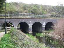
Long before today's pound locks were built on the main River Thames, the old waterways were controlled by 'flash locks', consisting of sluices or weirs with removable sections. Barges are believed to have once operated from wharves on both the main river and its side channels. Today the York Stream channel is narrow/shallow and prone to dry out at times of low flow on the main River Thames that feeds it. The Moor Cut channel is permanently 'dry', yet the signs for "Willow Wharf" can still be seen on the channel wall by the Police station at Town Moor.
The Moor Cut channel which crosses Town Moor was enlarged in the 1960s as part of the then flood defence system, long before the Jubilee River was built. The two channels rejoin at Green Lane and from there the waterway running down to the Thames is 45 to 50 feet (14 to 15 m) wide, but partly silted up. Channel clearance work over the last few years by volunteers and the Environment Agency has removed most of the tree blockages and it is already usable there by canoes and rowing boats.
The stream connects to the River Thames and retains public navigation rights, though it is impractical for boats to pass through the town sections today as they are silted up and overgrown. The old channel leaves the Thames just above Cliveden and eventually rejoins it just below Bray Lock by the Marina.
By October 2008, a long term renewal scheme was in progress, aiming to restore and upgrade the old waterways and allow boats into the centre of Maidenhead. The Maidenhead Waterways Restoration Group (MWRG) was founded in 2006, and became a private company limited by guarantee in March 2007,[1] with the aim of restoring the waterways to a navigable standard, allowing small boats to travel into and around the town centre 'ring'. A lock and weir at Green Lane would raise and stabilise water levels in the town centre channels and refill the dry Moor Cut channel of the waterway.
The Royal Borough of Windsor and Maidenhead set up the Partnership for the Rejuvenation of Maidenhead (PRoM) in 2008, which proposed a 20 Year Vision and Action Plan for rejuvenating the town centre. This led to development of a comprehensive Area Action Plan which after successive consultations was adopted in 2011. It sees the restored waterway as one of defining projects which will help improve and shape the identity of the town for the future.[2]
A planning application for Phase 1 of the waterways works was submitted to the Royal Borough of Windsor and Maidenhead by the Maidenhead Waterways Restoration Group in August 2011 and was approved in December 2012. The project then moved on to the detailed design stage,[3] in parallel with investigation of funding options. Area Action Plan development proposals for some of the key streamside sites were submitted during 2012 and were expected to help fund implementation of the waterway.[4] By mid-2014, stage 1 of the project, covering the section between the A4 road and the Great Western Railway arches, was fully scoped, and the Borough Council invited tenders for the £2.1 million project. Work was expected to commence in late October, but the tendering process took longer to complete, and the contract was eventually awarded to specialist water and environmental contractor Greenford Ltd.[5] Work on this first phase began in early 2015, and is expected to take 8 months to complete.[6] It is being funded by money from the Thames Valley Local Enterprise Partnership’s Growing Places loan fund, and by Section 106 money resulting from developments in the town centre.[7]
Waterways
- Fleet Ditch
- Strand Water
- York Stream
- Maidenhead Ditch
- Widbrook
- The Cut
- Maidenhead Flood Channel
- White Brook
See also
References
- ↑ "WebCHeck". Companies House.
- ↑ "Vision for Maidenhead". Royal Borough of Windsor and Maidenhead. Retrieved 14 February 2015.
- ↑ "History 2010 .....". Maidenhead Waterways Restoration Group. Retrieved 14 February 2015.
- ↑ "Flow Newsletter" (PDF). Maidenhead Waterways Restoration Group. October 2012.
- ↑ "Latest news". Maidenhead Waterways. Retrieved 14 February 2015.
- ↑ "Work begins on Thames Maidenhead Waterways Project". Waterways World. March 2015. ISSN 0309-1422.
- ↑ Meecham, Simon (15 December 2014). "Maidenhead Waterways work set to begin in January". Maidenhead Advertiser.
External links
- House of Commons debate on Thames Flood Alleviation Scheme
- Maidenhead Advertiser, 17/05/07, quoting Maidenhead Civic Society
- Maidenhead Waterways Restoration Group
- Maidenhead Civic Society on York Stream
| Next confluence upstream | River Thames | Next confluence downstream |
| River Wye (north) | Maidenhead Waterways | Clewer Mill Stream (south) |