Maiana
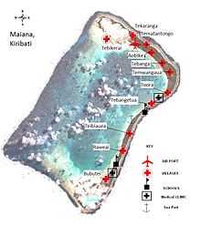 Map of Maiana | |
 | |
| Geography | |
|---|---|
| Location | Pacific Ocean |
| Coordinates | 0°55′N 173°00′E / 0.917°N 173.000°E |
| Archipelago | Gilbert Islands |
| Area | 16.72 km2 (6.46 sq mi) |
| Highest elevation | 3 m (10 ft) |
| Country | |
| Demographics | |
| Population | 2,027 (as of 2010 Census) |
| Density | 121 /km2 (313 /sq mi) |
| Ethnic groups | I-Kiribati 99.9% |
Maiana is an atoll in Kiribati and is one of the Central Gilbert Islands. Maiana is 44 kilometres (27 mi) south of the capital island of South Tarawa and has a population of 2,027 as of 2010. The northern and eastern sides of the atoll are a single island, whilst the western edge consists of submerged reefs and many uninhabited islets, all surrounding a lagoon. The atoll is 14 kilometres (8.7 mi) long and is very narrow, with an average width of less than 1 kilometre (0.62 mi) and a total land area (including uninhabited islets) of 16.72 square kilometres (6.46 sq mi).[1]
Geography


Most of the 2,027 people who live on Maiana live on the main island; the largest village is Bubutei, at the southern tip of the main island, which is home to 489 people or almost a quarter (24%) of the island’s total population. The population of Maiana is roughly stable and has been around 2,000 people since 1985.[1]
| Abaiang: Population and Land Area | |||
|---|---|---|---|
| Census Area | Population 2010[2] | Land area by islet[2] | Density (people per acre) |
| Tebikerai | 93 | 61.2 acres (25 ha) | 1.5 |
| Tebiauea | 211 | 3,805.6 acres (1,540 ha) | 0.5 |
| Raweai | 214 | ||
| Bubutei | 489 | ||
| Tekaranga | 139 | ||
| Tematantongo | 164 | ||
| Aobike | 110 | ||
| Tebanga | 264 | ||
| Temwangaua | 115 | ||
| Toora | 115 | ||
| Tebwangetua | 65 | ||
| Teitai | 48 | ||
| Uninhabited islets | 0 | 263.5 acres (107 ha) | 0 |
| Maiana total | 2,027 | 4,130.3 acres (1,671 ha) | 0.5 |
Climate change
Many parts of Maiana suffer from coastal erosion, with the villages of Tekaranga and Tematantongo being particularly affected. Drought is another serious concern as the island's limited freshwater supply comes entirely from the shallow freshwater lens, which becomes salty close to the coast especially during drought periods. Like all of the atolls of Kiribati, Maiana is at serious risk from sea level rise, as even small changes in sea level can cause accelerated erosion and threaten infrastructure, agriculture and water supplies.[1]
Administration
Maiana is administered by an Island Council based in Tebangetua village. The Maiana constituency elects two representatives to the national House of Assembly in the capital of South Tarawa. At present, the MPs for Maiana are Dr. Anote Tong and Teiwaki Areieta.[3] Dr. Tong is also the current President of Kiribati.
History
Maiana Post Office opened around 1925.[4]
Maiana Ferry Disaster
On 13 July 2009, the vessel Uean Te Raoi II, owned by the Catholic Parish of Maiana and travelling from Bwairiki in Tarawa, capsized and foundered off Maiana with the loss of 35 lives.[5]
References
- ↑ 1.0 1.1 1.2 "7. Maiana" (PDF). Office of Te Beretitent - Republic of Kiribati Island Report Series. 2012. Retrieved 28 April 2015.
- ↑ 2.0 2.1 "Kiribati Census Report 2010 Volume 1" (PDF). National Statistics Office, Ministry of Finance and Economic Development, Government of Kiribati.
- ↑ "Members of the Parliament of Kiribati for the Ninth Parliament", House of Assembly of Kiribati
- ↑ Premier Postal History. "Post Office List". Premier Postal Auctions. Retrieved 5 July 2013.
- ↑ "Beacon could have saved 33 lives in Kiribati accident". NZ Herald. 15 July 2010.
- Exhibit: The Alfred Agate Collection: The United States Exploring Expedition, 1838-1842 from the Navy Art Gallery
| |||||||||||||||||||||||||||||