Magoula, Attica
| Magoula Μαγούλα | |
|---|---|
 Magoula | |
|
Location within the regional unit 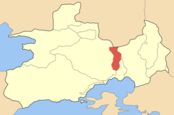 | |
| Coordinates: 38°5′N 23°31′E / 38.083°N 23.517°ECoordinates: 38°5′N 23°31′E / 38.083°N 23.517°E | |
| Country | Greece |
| Administrative region | Attica |
| Regional unit | West Attica |
| Municipality | Elefsina |
| • Municipal unit | 18.134 km2 (7.002 sq mi) |
| Elevation | 35 m (115 ft) |
| Population (2011)[1] | |
| • Municipal unit | 4,992 |
| • Municipal unit density | 280/km2 (710/sq mi) |
| Time zone | EET (UTC+2) |
| • Summer (DST) | EEST (UTC+3) |
| Postal code | 190 18 |
| Area code(s) | 210 |
| Vehicle registration | Z |
Magoula (Greek: Μαγούλα) is a town and former community (pop. 4,992 in 2011) of West Attica, Greece. Since the 2011 local government reform it is part of the municipality Eleusis, of which it is a municipal unit.[2]
Magoula is located 2 km east of Mandra, 5 km north of Eleusis and 21 km northwest of central Athens. The municipal unit of Magoúla also includes the village of Néos Póntos (pop. 257). Magoula is served by a station on the Athens Airport–Kiato railway. Motorway 6 runs southeast of the town.
Historical population
| Year | Town population | Municipal unit population |
|---|---|---|
| 1981 | 1,915 | - |
| 1991 | 2,663 | - |
| 2001 | 3,728 | 4,005 |
| 2011 | 4,735 | 4,992 |
Gallery
-
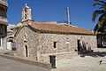
Agios Dimitrios orthodox church in Magoula
-
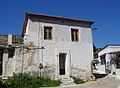
Traditional house in Magoula
References
- ↑ "Detailed census results 2011" (in Greek).
- ↑ Kallikratis law Greece Ministry of Interior (Greek)
External links
- GTP Travel Pages (Municipality) (in English and Greek)
 |
Dervenochoria | | ||
| Mandra | |
Aspropyrgos | ||
| ||||
| | ||||
| Eleusis | Eleusis |
| ||||||