Mae Suai District
| Mae Suai แม่สรวย | |
|---|---|
| Amphoe | |
 | |
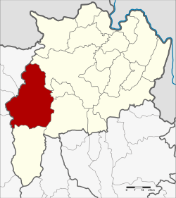 Amphoe location in Chiang Rai Province | |
| Coordinates: 19°39′23″N 99°32′33″E / 19.65639°N 99.54250°ECoordinates: 19°39′23″N 99°32′33″E / 19.65639°N 99.54250°E | |
| Country |
|
| Province | Chiang Rai |
| Area | |
| • Total | 1,428.61 km2 (551.59 sq mi) |
| Population (2008) | |
| • Total | 82,989 |
| • Density | 56.3/km2 (146/sq mi) |
| Time zone | THA (UTC+7) |
| Postal code | 57180 |
| Geocode | 5710 |
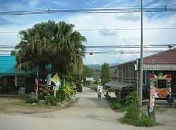
Mae Suai (Thai: แม่สรวย; IPA: [mɛ̂ː sǔaj]) is a district (amphoe) in the western part of Chiang Rai Province, northern Thailand.
Geography
Neighboring districts are (from the northeast clockwise) Mueang Chiang Rai, Mae Lao, Phan, Wiang Pa Pao, Phrao, Chai Prakan, Fang, Mae Ai of Chiang Mai Province.
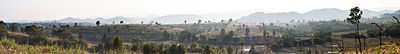
The Khun Tan Range stretches from north to south along the western side of the district. The Suai River, a tributary of the Lao River, gives its name to the district.
History
The district was created in 1905, when the districts Mueang Wiang Pa Pao and Mueang Phong were merged.[1] Originally spelled แม่ซ่วย, the current spelling was adopted before 1917.
Administration
The district is subdivided into 7 subdistricts (tambon), which are further subdivided into 128 villages (muban). Mae Suai and Chedi Luang are two subdistrict municipalities (thesaban tambon) which each cover part of the same-named tambon. There are further 9 Tambon administrative organizations (TAO).
| No. | Name | Thai | Villages | Inh.[2] |
|---|---|---|---|---|
| 1. | Mae Suai | แม่สรวย | 17 | 9,058 |
| 2. | Pa Daet | ป่าแดด | 22 | 11,018 |
| 3. | Mae Phrik | แม่พริก | 13 | 5,808 |
| 4. | Si Thoi | ศรีถ้อย | 12 | 6,198 |
| 5. | Tha Ko | ท่าก๊อ | 27 | 18,597 |
| 6. | Wawi | วาวี | 25 | 24,996 |
| 7. | Chedi Luang | เจดีย์หลวง | 12 | 7,314 |
References
- ↑ แจ้งความกระทรวงมหาดไทย. Royal Gazette (in Thai) 22 (39): 950–951. 1905-12-24.
- ↑ "Population statistics 2008". Department of Provincial Administration.
External links
| ||||||||||||||||||||