Mae Sot District
| Mae Sot แม่สอด | |
|---|---|
| Amphoe | |
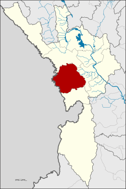 Amphoe location in Tak Province | |
| Coordinates: 16°42′47″N 98°34′29″E / 16.71306°N 98.57472°ECoordinates: 16°42′47″N 98°34′29″E / 16.71306°N 98.57472°E | |
| Country |
|
| Province | Tak |
| Area | |
| • Total | 1,986.1 km2 (766.8 sq mi) |
| Population (2008) | |
| • Total | 120,569 |
| • Density | 60.71/km2 (157.2/sq mi) |
| Time zone | THA (UTC+7) |
| Postal code | 63110 |
| Geocode | 6306 |

Mae Sot (Thai: แม่สอด, pronounced [mɛ̂ː sɔ̀ːt]; Burmese: မဲဆောက်, [mɛ́ sʰaʊʔ]; Shan: ႄႈသၢႆ, [ɛ sʰaaj]) is a district in western Thailand that shares a border with Burma to the west. It is notable as a trade hub and for its substantial population of Burmese migrants and refugees. The town is part of Tak Province and is the main gateway between Thailand and Burma. As a result it has gained notoriety for its trade in gems and teak, as well as black market services such as people trafficking and drugs. Neighbouring districts are (from north clockwise): Mae Ramat, Mueang Tak, and Phop Phra. The Moei River serves as a natural border between Mae Sot and the Burmese town of Myawaddy.
Gateway to Burma
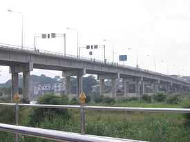
Mae Sot is the where Asian Highway AH1 links Thailand and Burma. It is one of only two transnational roads and cross-border points across the Tenasserim Hills to Burma, along with Three Pagodas Pass. The Thai-Myanmar Friendship Bridge crossing the Moei River was constructed in 1997 completing the link between the two countries.[1] At the entrance of the bridge is the immigration office which is open from 06:00 to 18:00.
As a gateway city, Mae Sot has its own domestic airport. But due to high fuel costs, some airlines such as Phuket Air have cancelled their flights between Bangkok and Mae Sot.
Every year, Tak Chamber of Commerce organizes a friendship bicycle rally to Myawaddy.
Link to India
India's foreign minister met with Myanmar's construction minister in Delhi on the 22 February 2012, and spoke about opening a highway between Moreh, India, and the Myanmar-Thai border near Mae Sot.[2]
Economy
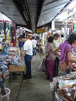
Trade with Burma constitutes the largest portion of Mae Sot's economy. It has an established market for commodities such as wholesale gems and teak. Most of the town's service industries are supported by Burmese migrants who work in sweat-shops and factories throughout the region. The town also suffers from a black market in illegal smuggling, people trafficking, and narcotics. The Thai-Myanmar Friendship Bridge is the primary gateway for trade with Burma. The border region, several kilometres west from central Mae Sot, includes the Rim Moei Market that deals in imported goods and woodwork.
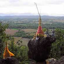
Mae Sot serves as a minor tourist destination, primarily used for those wishing to visit Myawaddy in Burma or as a stopover on the way to Amphoe Umphang, popular for trekking.
Burmese refugees
The town has a substantial population of Burmese refugees and economic migrants. The exact number of Burmese in Mae Sot is unclear, but estimates say that over 100,000 exist in addition to the 106,000 already recorded in the official census. In recent years the ongoing refugee situation has prompted NGOs and international aid agencies to establish programmes in the town and surrounding area.
One of the most notable organizations is the Mae Tao Clinic, just outside the west of town. It was established by the Burmese/Karen Dr Cynthia Maung to offer free medical services to Burmese who do not qualify for treatment at the Mae Sot Hospital. The centre is funded independently and is supported by teams of volunteers.[3]
The Mae Sot region has around 70 migrant schools that started spontaneously to meet the needs of the 30,000 children who have crossed the border with their parents from Burma. The students are a mix of refugees and economic migrants. Of this number only 7,000 currently attend school. The schools range in size from 20 to over 650 students (Hsa Thoo Lei School). These schools receive no support from the Thai government and rely solely on their resourcefulness and international support.
Human rights abuses
Serious human rights abuses have been reported here and in the province, whereby local Thai police collude with local business and mafia in trafficking Burmese slave labour, after decades of massive refugee camps accumulating on the Thai side of the border.
Administration
The district (Amphoe) Mae Sot is subdivided into 10 subdistricts (Tambon), which are further subdivided into 86 villages (muban). The city (thesaban nakhon) Mae Sot covers the whole tambon Mae Sot. Tha Sai Luat and Mae Ku are subdistrict municipalities (thesaban tambon). There are further 9 tambon administrative organizations (TAO).
| No. | Name | Thai name | ||||||
|---|---|---|---|---|---|---|---|---|
| 1. | Mae Sot | แม่สอด | 6. | Tha Sai Luat | ท่าสายลวด | |||
| 2. | Mae Ku | แม่กุ | 7. | Mae Pa | แม่ปะ | |||
| 3. | Phawo | พะวอ | 8. | Mahawan | มหาวัน | |||
| 4. | Mae Tao | แม่ตาว | 9. | Dan Mae La Mao | ด่านแม่ละเมา | |||
| 5. | Mae Kasa | แม่กาษา | 10. | Phra That Pha Daeng | พระธาตุผาแดง |
There are plans to create a new province centred in Mae Sot, covering the 5 border districts of Tak Province.[4][5] Additionally the town is planned to be converted into a metropolis, covering the tambon Mae Sot, Mae Pa, and Tha Sai Luat.[6]
Climate
Mae Sot has a tropical savanna climate (Köppen climate classification Aw). Winters are dry and very warm. Temperatures rise until April, which is very hot with the average daily maximum at 36.8 °C (98.2 °F). The monsoon season runs from May to October, with heavy rain and somewhat cooler temperatures during the day, although nights remain warm.
| Climate data for Mae Sot (1981–2010) | |||||||||||||
|---|---|---|---|---|---|---|---|---|---|---|---|---|---|
| Month | Jan | Feb | Mar | Apr | May | Jun | Jul | Aug | Sep | Oct | Nov | Dec | Year |
| Average high °C (°F) | 31.6 (88.9) |
34.0 (93.2) |
35.8 (96.4) |
36.8 (98.2) |
34.1 (93.4) |
31.4 (88.5) |
30.5 (86.9) |
30.3 (86.5) |
31.5 (88.7) |
32.2 (90) |
31.5 (88.7) |
30.4 (86.7) |
32.51 (90.51) |
| Average low °C (°F) | 15.3 (59.5) |
16.7 (62.1) |
19.8 (67.6) |
23.1 (73.6) |
23.9 (75) |
23.6 (74.5) |
23.2 (73.8) |
23.1 (73.6) |
23.2 (73.8) |
22.3 (72.1) |
19.2 (66.6) |
15.5 (59.9) |
20.74 (69.34) |
| Average rainfall mm (inches) | 1.7 (0.067) |
8.2 (0.323) |
15.5 (0.61) |
44.8 (1.764) |
174.9 (6.886) |
255.4 (10.055) |
329.0 (12.953) |
321.7 (12.665) |
185.4 (7.299) |
102.1 (4.02) |
23.7 (0.933) |
5.9 (0.232) |
1,468.3 (57.807) |
| Avg. rainy days (≥ 1 mm) | 1 | 1 | 1 | 5 | 17 | 26 | 27 | 27 | 21 | 14 | 4 | 1 | 145 |
| Average relative humidity (%) | 72 | 65 | 61 | 64 | 76 | 84 | 86 | 87 | 85 | 82 | 77 | 74 | 76.1 |
| Source: Thai Meteorological Department (Normal 1981-2010), (Avg. rainy days 1961-1990) | |||||||||||||
References
- ↑ "Asian Highway". Development of the Asian Highway. Asian Highway. Retrieved 2008-08-26.
- ↑ "In India's Northeast, Peace and Foreign Ties Quietly Spread". The New York Times. 2012-03-13.
- ↑ "Mae Tao Clinic". Mae Tao Clinic. 2007. Retrieved 2008-09-07.
- ↑ "MaeSot in Thailand". MaeSot in Thailand. Retrieved 2011-07-27.
- ↑ อปท.5 อ.ชายแดนตาก ดันตั้ง "จว.77-มหานคร" เสนอ "3 พล.อ.-สนช." หลังดันมา 5 ปีแต่ไม่คืบ (in Thai). Manager Online. Retrieved 2009-04-26.
- ↑ "Mae Sot Metropolis Plan". The Irrawaddy. Retrieved 2009-04-26.
External links
| Wikimedia Commons has media related to Mae Sot District. |
 Mae Sot travel guide from Wikivoyage
- MaeSot in Thailand
- Hoping for freedom in Mae Sot: an audio documentary.
- Asian Highway
- Tak Chamber (Thai)
| ||||||