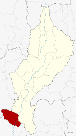
Mae Phrik District
| Mae Phrik แม่พริก | |
|---|---|
| Amphoe | |
 Amphoe location in Lampang Province | |
| Coordinates: 17°26′54″N 99°6′54″E / 17.44833°N 99.11500°ECoordinates: 17°26′54″N 99°6′54″E / 17.44833°N 99.11500°E | |
| Country |
|
| Province | Lampang |
| Seat | Mae Phrik |
| Area | |
| • Total | 538.921 km2 (208.079 sq mi) |
| Population (2008) | |
| • Total | 17,149 |
| • Density | 31.8/km2 (82/sq mi) |
| Time zone | THA (UTC+7) |
| Postal code | 52180 |
| Geocode | 5209 |
Mae Phrik (Thai: แม่พริก; IPA: [mɛ̂ː pʰrík]) is a district (amphoe) in the southern part of Lampang Province, northern Thailand.
Geography
Neighboring districts are (from the northeast clockwise): Thoen of Lampang Province, Sam Ngao of Tak Province and Li of Lamphun Province.
History
Mae Phrik was created in 1904 as a minor district (King Amphoe), subordinate of Thoen district. It was upgraded to a full district in 1958.[1]
Administration
The district is subdivided into 4 subdistricts (tambon), which are further subdivided into 29 villages (muban). There are two subdistrict municipalities (thesaban tambon) - Mae Phrik covers parts of tambon Mae Phrik, and Mae Pu the whole tambon Mae Pu. There are further 2 Tambon administrative organizations (TAO).
| No. | Name | Thai | Villages | Inh.[2] |
|---|---|---|---|---|
| 1. | Mae Phrik | แม่พริก | 10 | 7,045 |
| 2. | Pha Pang | ผาปัง | 5 | 1,903 |
| 3. | Mae Pu | แม่ปุ | 6 | 4,316 |
| 4. | Phra Bat Wang Tuang | พระบาทวังตวง | 8 | 3,885 |
References
- ↑ พระราชกฤษฎีกาจัดตั้งอำเภอกระสัง อำเภอกระนวน อำเภอบางกอกใหญ่ อำเภอขุนหาร อำเภอพนา อำเภอปากช่อง อำเภอวังเหนือ อำเภอวังชิ้น อำเภอแม่ทา อำเภอหนองหมู อำเภอสระแก้ว อำเภออมก๋อย อำเภอบางซ้าย อำเภอทับสะแก อำเภอบุณฑริก อำเภอลานสะกา อำเภอจอมบึง อำเภอท่ายาง อำเภอสามเงา อำเภอฟากท่า อำเภอบ้านเขว้า อำเภอชานุมาน อำเภอแม่พริก อำเภอท่าสองยาง อำเภอสะเมิง อำเภอหนองแขม อำเภอพระแสง พ.ศ. ๒๕๐๑. Royal Gazette (in Thai) 75 (55 ก): 321–327. 1958-07-22.
- ↑ "Population statistics 2008". Department of Provincial Administration.
External links
- amphoe.com (Thai)
| ||||||