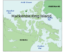
Mackenzie King Island
 Mackenzie King Island and Borden Island | |
 | |
| Geography | |
|---|---|
| Location | Northern Canada |
| Coordinates | 77°45′N 112°00′W / 77.750°N 112.000°WCoordinates: 77°45′N 112°00′W / 77.750°N 112.000°W |
| Archipelago |
Queen Elizabeth Islands Canadian Arctic Archipelago |
| Area | 5,048 km2 (1,949 sq mi) |
| Length | 61 mi (98 km) |
| Width | 60 mi (100 km) |
| Country | |
| Territory |
Nunavut Northwest Territories |
| Demographics | |
| Population | 0 |
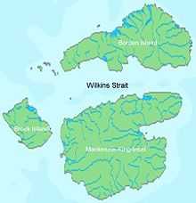
Mackenzie King Island is one of the Queen Elizabeth Islands in northern Canada. It lies north of Melville Island and south of Borden Island, and like them is divided. Most of the island is in Northwest Territories, while its easternmost portion lies in Nunavut. The border runs along the 110th meridian west.
Mackenzie King has an area of 5,048 km2 (1,949 sq mi), 60 miles (97 km) long in northeast or 47 miles (76 km) in southeast and 60 miles (97 km) wide, making it the 116th largest island in the world, and Canada's 26th largest island.
History
The first known visit to the island was by Vilhjalmur Stefansson in 1915, and it was later named for William Lyon Mackenzie King.[1]
References
- ↑ "King, The Right Hon. William Lyon Mackenzie". parl.gc.ca. Retrieved 2008-05-18.
Further reading
- Vilks, G. Foraminiferal Study of East Bay, Mackenzie King Island, District of Franklin (Polar Continental Shelf Project). [Ottawa]: Dept. of Mines and Technical Surveys, 1964.
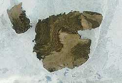
Terra MODIS satellite image of Mackenzie Island, Canada. Brock Island is on the left
External links
| ||||||||||||||||||||||