Machézal
| Machézal | |
|---|---|
|
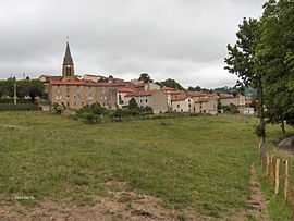
A general view of Machézal | |
 Machézal | |
|
Location within Rhône-Alpes region  Machézal | |
| Coordinates: 45°55′21″N 4°18′11″E / 45.9225°N 4.3031°ECoordinates: 45°55′21″N 4°18′11″E / 45.9225°N 4.3031°E | |
| Country | France |
| Region | Rhône-Alpes |
| Department | Loire |
| Arrondissement | Roanne |
| Canton | Saint-Symphorien-de-Lay |
| Intercommunality | Communauté de communes du Pays entre Loire et Rhône |
| Area1 | 13.88 km2 (5.36 sq mi) |
| Population (1999)2 | 361 |
| • Density | 26/km2 (67/sq mi) |
| INSEE/Postal code | 42128 / 42114 |
| Elevation |
470–882 m (1,542–2,894 ft) (avg. 625 m or 2,051 ft) |
|
1 French Land Register data, which excludes lakes, ponds, glaciers > 1 km² (0.386 sq mi or 247 acres) and river estuaries. 2 Population without double counting: residents of multiple communes (e.g., students and military personnel) only counted once. | |
Machézal is a commune in the Loire department in central France.
See also
| Wikimedia Commons has media related to Machézal. |