Mace, Indiana
| Mace | |
|---|---|
| Unincorporated community | |
|
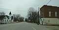
Corner of Main Street and 600 East on the east side of Mace. | |
 Mace Location in Montgomery County | |
| Coordinates: 40°00′37″N 86°47′47″W / 40.01028°N 86.79639°WCoordinates: 40°00′37″N 86°47′47″W / 40.01028°N 86.79639°W | |
| Country | United States |
| State | Indiana |
| County | Montgomery |
| Township | Walnut |
| Elevation | 840 ft (260 m) |
| ZIP code | 47933 |
| FIPS code | 18-45720[1] |
| GNIS feature ID | 438449[2] |

Mace is an unincorporated community in Walnut Township, Montgomery County, Indiana.
History
Mace, formerly called Fredericksburg, was laid out in about 1840 by Frederick Long.[3]
Geography
Mace is located at 40°00′37″N 86°47′47″W / 40.01028°N 86.79639°W.
References
- ↑ "American FactFinder". United States Census Bureau. Retrieved 2008-01-31.
- ↑ "Mace, Indiana". Geographic Names Information System. United States Geological Survey. Retrieved 2009-10-17.
- ↑ Beckwith, Hiram Williams and Kennedy, P. S. (1881). History of Montgomery County, Together with Historic Notes on the Wabash Valley. H. H. Hill and N. Iddings. p. 372.
Gallery
-
Looking east along U.S. Route 136 into Mace
-

Mace Cemetery
| |||||||||||||||||||||||||||||