MacCabe Corner
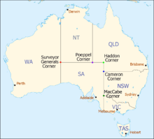
AUS map with named state corners
MacCabe Corner is the point at which the borders of the state of South Australia, Victoria and New South Wales meet.[1] It is 82km west of the town of Wentworth, NSW, on a bend of the Murray River.[1]
MacCabe Corner is named for Francis MacCabe, a surveyor who did considerable work exploring and mapping NSW, in particular the rivers of the Murray-Darling basin.[1]
| Corners in Australia | |||||
|---|---|---|---|---|---|
| Name | Surveyor Generals | Poeppel | Haddon | Cameron | MacCabe |
| States | WA/NT/SA | NT/SA/Qld | SA/Qld | SA/Qld/NSW | SA/Vic/NSW |
References
- ↑ 1.0 1.1 1.2 Pia Akerman (6 September 2008). "Tribute to pioneer who left his mark on all he surveyed". The Australian. News Limited. Retrieved 29 October 2014.