Maarssen
| Maarssen | |||
|---|---|---|---|
| Town and former municipality | |||
 | |||
| |||
 | |||
| Coordinates: 52°08′07″N 5°02′29″E / 52.135144°N 5.041297°ECoordinates: 52°08′07″N 5°02′29″E / 52.135144°N 5.041297°E | |||
| Country | Netherlands | ||
| Province | Utrecht | ||
| Municipality | Stichtse Vecht | ||
| Area(2006) | |||
| • Total | 30.86 km2 (11.92 sq mi) | ||
| • Land | 27.20 km2 (10.50 sq mi) | ||
| • Water | 3.66 km2 (1.41 sq mi) | ||
| Population (1 January, 2007) | |||
| • Total | 39,363 | ||
| • Density | 1,447/km2 (3,750/sq mi) | ||
| Source: CBS, Statline. | |||
| Time zone | CET (UTC+1) | ||
| • Summer (DST) | CEST (UTC+2) | ||
| Website | www.maarssen.nl | ||
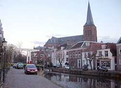
Maarssen (![]() pronunciation ) is a town in the middle of the Netherlands, in the province of Utrecht, along the river Vecht and the Amsterdam–Rhine Canal. The west of Maarssen is called Maarssen-Broek[1] whereas the east is called Maarssen-Dorp. Both put together and joined by other small towns around provide the area of Maarssen.
pronunciation ) is a town in the middle of the Netherlands, in the province of Utrecht, along the river Vecht and the Amsterdam–Rhine Canal. The west of Maarssen is called Maarssen-Broek[1] whereas the east is called Maarssen-Dorp. Both put together and joined by other small towns around provide the area of Maarssen.
On January 1, 2011 Maarssen merged with the councils of Breukelen and Loenen to become the Stichtse Vecht.
Population centres
The former municipality of Maarssen consisted of the following cities, towns, villages and/or districts:
- Maarssen (colloquially "Maarssen-dorp") and Maarssen-Broek
- Maarssenbroek
- Maarsseveen
- Molenpolder
- Oud-Maarsseveen
- Oud-Zuilen
- Tienhoven
Transportation
References
- ↑ Statistics are taken from the SDU Staatscourant
External links
| Wikimedia Commons has media related to Maarssen. |