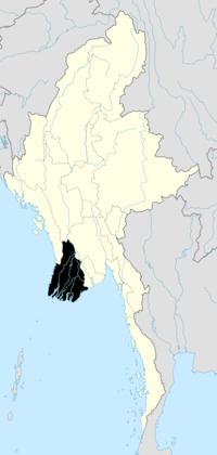
Ma-ubin Township
| Ma-ubin Township မအူပင်မြို့နယ် | |
|---|---|
| Township | |
 Ma-ubin Township Location in Burma | |
| Coordinates: 16°44′N 95°39′E / 16.733°N 95.650°ECoordinates: 16°44′N 95°39′E / 16.733°N 95.650°E | |
| Country |
|
| Region | Ayeyarwady Region |
| District | Ma-ubin District |
| Administrative seat | Maubin |
| Population (December 2008)[1] | 309,921 |
| Time zone | MST (UTC+6:30) |
Maubin Township (Burmese: မအူပင် မြို့နယ် [məʔùbɪ̀ɴ mjo̰nɛ̀]) is a township of Maubin District in the Ayeyarwady Region of Burma (Myanmar).
Communities
There are 76 village tracts comprising 470 villages in Maubin Township.[1]
Notes
- ↑ 1.0 1.1 "Profile Maubin Township" Myanmar Information Management Unit (MIMU), March 2009
External links
- "Maubin Township, Village Tracts" map created August 2010, Myanmar Information Management Unit (MIMU)
- "Ma-Ubin Google Satellite Map" Maplandia World Gazetteer
| ||||||||||
