MIMAROPA
| Region IV-B MIMAROPA Southern Tagalog islands | |
|---|---|
| Region | |
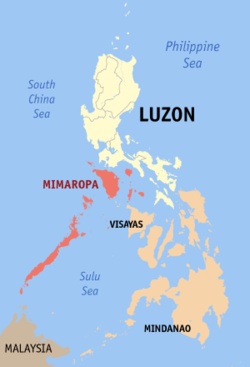 Location in the Philippines | |
| Country | Philippines |
| Island group | Luzon |
| Regional center | Calapan City, Oriental Mindoro |
| Area | |
| • Total | 29,621 km2 (11,437 sq mi) |
| Population (2010)[1] | |
| • Total | 2,744,671 |
| • Density | 93/km2 (240/sq mi) |
| Time zone | PST (UTC+8) |
| Provinces | 5 |
| Cities | 2 |
| Municipalities | 71 |
| Barangays | 1458 |
| Cong. districts | 7 |
| Languages | Tagalog, Romblomanon, Bantoanon or Asi, Onhan, Cuyonon, English, others |
Coordinates: 10°40′N 119°30′E / 10.667°N 119.500°E MIMAROPA is an administrative region in the Philippines, designated as Region IV-B. It is one of two regions in the country having no land border with another region, the other being Eastern Visayas. The name is an acronym combination of its constituent provinces, which are: Mindoro (divided into Occidental Mindoro and Oriental Mindoro), Marinduque, Romblon and Palawan. The region is also formally known as the Southern Tagalog Islands.[2]
Calapan City is the regional center. However, most regional government offices such as the Department of Public Works and Highways[3] are in the city of Quezon in Metro Manila.
The region was part of the now-defunct Southern Tagalog region until May 17, 2002.[4] On May 23, 2005, Palawan and the highly urbanized city of Puerto Princesa were moved to the region of Western Visayas by Executive Order No. 429.[5] However, on August 19, 2005, then-President Arroyo issued Administrative Order No. 129 to hold the earlier EO 429 in abeyance pending a review.[6]
History
Region IV-B, together with Region IV-A, were officially created with the partitioning of Region IV (Southern Tagalog) into the two regions on May 17, 2002 with the issuance of Executive Order 103 (EO103) by then-President Gloria Macapagal-Arroyo; for the purpose of promoting efficiency in the government, accelerating social and economic development and improving public services in the provinces covered. Region IV-B was designated as MIMAROPA, which stands for the island provinces belonging to the Southern Tagalog region — Mindoro (Oriental and Occidental), Marinduque, Romblon and Palawan.[4]
On May 23, 2005, Executive Order 429 was issued, moving the province of Palawan to the region of Western Visayas,[5] designating Region IV-B as MIMARO. However, Palawan residents criticized the move, citing a lack of consultation, with most residents in Puerto Princesa City and nearly all municipalities preferring to stay with Region IV-B. Consequently, Administrative Order No. 129 was issued on August 19, 2005 to address this backlash. This order directed the abeyance of Executive Order 429 pending the approval of an implementation plan for the orderly transfer of Palawan from MIMAROPA to Region VI.[6]
The 2010 Philippine Census of Population reported the region name as 'Mimaropa' and included the province of Palawan as part of the region.[7] As of 2014, it is not clear whether the transfer of Palawan to region VI is still considered pending by the Philippine government. As of 2014, the National Statistical Coordinating Board of the Philippines continued to list Palawan province as part of the MIMAROPA region.[8]
Demographics
| Population census of MIMAROPA | ||
|---|---|---|
| Year | Pop. | ±% |
| 1990 | 1,774,074 | — |
| 2000 | 2,299,229 | +29.6% |
| 2010 | 2,744,671 | +19.4% |
| Source: National Statistics Office[1] | ||
Languages
Tagalog is widely spoken in the region. In Marinduque, the language is spoken with a unique blend of Bicolano and Visayan languages. Aside from Tagalog, there are other major languages being used by the people in different provinces and localities.
In the interior of Mindoro, various languages are spoken by Mangyans, and they include Iraya, Alangan, Tawbuid, Hanunoo, Tadyawan, Buhid, and Ratagnon. The latter is a Visayan language with fewer than three speakers. Romblon, being near the Visayas, has three main languages that belong to Visayan language family namely, Romblomanon, Asi, and Onhan. Palawan has its own set of native languages such as Cuyonon, Calamian Tagbanwa and Palawano that are spoken by significant numbers of people.
Economy
In 2007, MIMAROPA's economy surged by 9.4%, making it the fastest growing region in the country in that year.[9] It was aided by robust growth in the industrial sector which grew by 19.1% from -6.1% in 2006.[9]
MIMAROPA experienced a big slowdown in 2006, posting a decelerated growth of 2.3% from a 6.4% increase in 2005. This resulted mainly from the slump in the industry sector, which shrunk by 5.4% in 2006 from its 10.8% increase in 2005.
The agriculture, forestry, and fishing sector, which contributed 42.1% to the total regional economy, grew by 9.1% in 2006, accelerating from 3.2% the previous year. The higher production of palay, corn, other crops, livestock and fishery resulted in the accelerated growth in the total agriculture and fishery sector.
The industry sector, which contributed 38.3% to the region’s total economy, was the second largest contributor next to agriculture. Its decline of 5.4% was largely attributed to the decrease in the mining and quarrying sub-sector, which went down by 15.4% due to the reduced production of natural gas in Palawan. Mining and quarrying contributed 16.6% to the total regional economy. The positive growth in the electricity and water, construction and manufacturing sub-sectors were not able to compensate to the drop in the mining and quarrying sub-sector.
The service sector, on the other hand, posted an accelerated growth of 5.1%, which was attributed to the increase in the TCS, finance, private services, government services and trade sub-sectors, which managed to post accelerated growths of 6.0%, 5.5%, 5.1%, 5.1% and 4.7%, respectively. The other sub-sector, however, had a decelerated growth due to the slowdown in the ownership of dwelling.
Political divisions
MIMAROPA is divided into five provinces. It consists of one highly urbanized city and one component city.
Provinces

| Province | Capital | Population (2010)[1] |
Area (km²) |
Governor | |
|---|---|---|---|---|---|
 |
Marinduque | Boac | 227,828 | 952.58 | Carmencita O. Reyes |
 |
Occidental Mindoro | Mamburao | 452,971 | 5,865.7 | Mario Gene Mendiola |
 |
Oriental Mindoro | Calapan City | 785,602 | 4,238.4 | Alfonso Umali, Jr. |
 |
Palawan | Puerto Princesa City | 771,667 | 14,649.7 | Jose C. Alvarez |
 |
Romblon | Romblon | 283,930 | 1,533.5 | Eduardo C. Firmalo |
Cities
| City | Province | City Class | Income Class | Population (2010) |
Area (km²) |
Mayor | |
|---|---|---|---|---|---|---|---|
 |
Puerto Princesa CityA | Palawan (Geographically) |
Highly Urbanized | 1st Class | 222,673 | 2,381.02 | Lucilo R. Bayron |
| Calapan City | Oriental Mindoro | Component | 3rd Class | 124,173 | 250.06 | Arnan C. Panaligan | |
A Figures for Puerto Princesa, which became a highly urbanized city in 2007 pursuant to Presidential Proclamation No. 1264,[10] do not accrue to Palawan province.
Tourism
There are many scenic spots in the MIMAROPA. Some of them are the Bathala Cave, Balanacan Bay and Tres Reyes Islands in the province of Marinduque; the White Island in Mindoro; Bonbon Beach in Romblon; and, the Puerto Princesa Subterranean River National Park and El Nido Marine Reserve Park in Palawan.
References
- ↑ 1.0 1.1 1.2 "Population and Annual Growth Rates for The Philippines and Its Regions, Provinces, and Highly Urbanized Cities". 2010 Census and Housing Population. National Statistics Office. Retrieved 9 August 2013.
- ↑ "EMB Central and Regional Offices". Department of Environment and Natural Resources - Environmental Management Bureau. Retrieved 2 November 2014.
- ↑ "Region IV-B Directory: Regional Office Directory". Department of Public Works and Highways. Retrieved 2 November 2014.
- ↑ 4.0 4.1 "Executive Order No. 103: Dividing Region IV into Region IV-A and Region IV-B, Transferring the Province of Aurora to Region III and for Other Purposes". Philippine Statistics Authority - National Statistical Coordination Board. Retrieved 1 November 2014.
- ↑ 5.0 5.1 "Executive Order No. 429: Providing for the Reorganization of Administrative Region VI to Include the Province of Palawan and Puerto Princesa City". Philippine Statistics Authority - National Statistical Coordination Board. Retrieved 1 November 2014.
- ↑ 6.0 6.1 "Administrative Order no. 129". National Statistical Coordination Board. Retrieved on 2011-03-22.
- ↑ "Population and Annual Growth Rates by Province, City, and Municipality : Region IVB - MIMAROPA: 1990, 2000, and 2010". 2010 Philippine Census of Population. census.gov.ph.
- ↑ "Region: REGION IV-B (MIMAROPA)". National Statistical Coordinating Board of the Philippines. Archived from the original on 2014-08-21. Retrieved 2012-05-26.
- ↑ 9.0 9.1 "NSCB - 2007 Gross Regional Domestic Product". National Statistical Coordination Board. 28 July 2008. Retrieved 2009-05-18.
- ↑ "Puerto Princesa to hold plebiscite simultaneous with May 14 elections" (Press release). Philippine Information Agency. April 27, 2007.
| Wikimedia Commons has media related to MIMAROPA. |
| ||||||||||||||
| ||||||||||||||||||||||||||||||||||

