Münstermaifeld
| Münstermaifeld | ||
|---|---|---|
| ||
 Münstermaifeld | ||
Location of Münstermaifeld within Mayen-Koblenz district 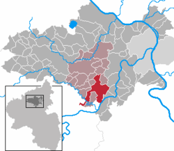 | ||
| Coordinates: 50°14′51″N 7°21′47″E / 50.24750°N 7.36306°ECoordinates: 50°14′51″N 7°21′47″E / 50.24750°N 7.36306°E | ||
| Country | Germany | |
| State | Rhineland-Palatinate | |
| District | Mayen-Koblenz | |
| Municipal assoc. | Maifeld | |
| Government | ||
| • Mayor | Robert Müller (WG Pro-MM) | |
| Area | ||
| • Total | 27.78 km2 (10.73 sq mi) | |
| Population (2012-12-31)[1] | ||
| • Total | 3,498 | |
| • Density | 130/km2 (330/sq mi) | |
| Time zone | CET/CEST (UTC+1/+2) | |
| Postal codes | 56294 | |
| Dialling codes | 02605 | |
| Vehicle registration | MYK | |
| Website | www.muenstermaifeld.de | |

Münstermaifeld (German pronunciation: [ˌmʏnstɐˈmaɪfɛlt]) is a town in the district Mayen-Koblenz, in Rhineland-Palatinate, Germany. It is part of the Verbandsgemeinde ("collective municipality") Maifeld. It is situated south-east of Mayen, a few km from the Moselle River and the castle Eltz. The first (b.c.) residents of the region were Celts. The old church is based on a Roman castle-tower. After the Romans, the Franks (Charlemagne) arrived in the 9th century. In the Middle Ages (1277) Münstermaifeld received town privileges and was governed by the bishop of Trier. It is one of the oldest towns in Rhineland-Palatinate and, with its 3,400 citizens, one of the smallest.
References
- ↑ "Bevölkerung der Gemeinden am 31.12.2012". Statistisches Bundesamt (in German). 2013.
-
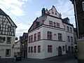
Town hall of Münstermaifeld
-
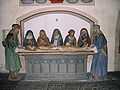
"Holy Sepulchre - Entombment of Christ" sculpture in the Maifeldmünster church
External links
| Wikimedia Commons has media related to Münstermaifeld. |