Möll
| Möll | |
|---|---|
 Upper Möll near Heiligenblut | |
| Origin |
Grossglockner 47°4′39″N 12°44′4″E / 47.07750°N 12.73444°E |
| Mouth |
Drava near Möllbrücke 46°49′38″N 13°22′48″E / 46.82722°N 13.38000°ECoordinates: 46°49′38″N 13°22′48″E / 46.82722°N 13.38000°E |
| Progression | Drava → Danube → Black Sea |
| Basin countries | Austria |
| Length | 84 km (52 mi) |
| Source elevation | 2,500 metres (8,200 ft) |
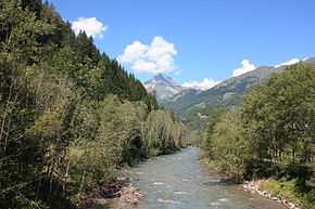
The Möll (presumably from Slovene: Mel, "rubble") is a left tributary of the Drava River in northwestern Carinthia in Austria.
Course
It rises in the Hohe Tauern mountain range at the foot of the Grossglockner, the highest mountain in Austria, and discharges after 84 km (52 mi) near Möllbrücke into the Drava. At the beginning of its course, at the southeastern end of the Pasterze Glacier, it is impounded to form the Margaritze Reservoir, from where part of the water is diverted across the Alpine divide to the reservoirs of Kaprun Power Station.
The Möll runs down to Heiligenblut parallel to the Grossglockner High Alpine Road and further downstream is again impounded near Stall into the Gößnitz Reservoir and near Kolbnitz to create the Rottau equalizing basin. From the latter, some of the water is diverted to the lower stage of the Malta-Reisseck Power Plant Group in Möllbrücke.
The Möll is a popular kayak white water river and one of the preferred rafting rivers in Carinthia.
External links
| Wikimedia Commons has media related to Möll. |
Gallery
-
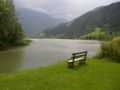
Gößnitz Reservoir
-
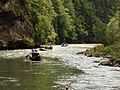
Rafting near Napplach
-
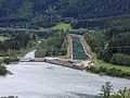
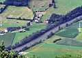
Rottau equalizing basin. Right: the Oberwasser channel, that leads to Möll Valley Power Station. Left: the natural river bed though which only a fraction of the water flows.
-
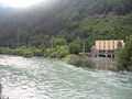
Möll Valley Power Station. The water now empties into the Drau before the actual mouth of the Möll (left).