Ménétréol-sous-Sancerre
| Ménétréol-sous-Sancerre | |
|---|---|
|
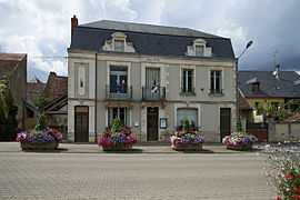
The town hall in Ménétréol-sous-Sancerre | |
 Ménétréol-sous-Sancerre | |
|
Location within Centre region  Ménétréol-sous-Sancerre | |
| Coordinates: 47°19′07″N 2°51′24″E / 47.3186°N 2.8567°ECoordinates: 47°19′07″N 2°51′24″E / 47.3186°N 2.8567°E | |
| Country | France |
| Region | Centre-Val de Loire |
| Department | Cher |
| Arrondissement | Bourges |
| Canton | Sancerre |
| Government | |
| • Mayor (2001–2008) | Roger Laurent |
| Area1 | 5.67 km2 (2.19 sq mi) |
| Population (2008)2 | 378 |
| • Density | 67/km2 (170/sq mi) |
| INSEE/Postal code | 18146 / 18300 |
| Elevation |
142–252 m (466–827 ft) (avg. 185 m or 607 ft) |
|
1 French Land Register data, which excludes lakes, ponds, glaciers > 1 km² (0.386 sq mi or 247 acres) and river estuaries. 2 Population without double counting: residents of multiple communes (e.g., students and military personnel) only counted once. | |
Ménétréol-sous-Sancerre is a commune in the Cher department in the Centre region of France.
Geography
A winegrowing and farming village situated by the banks of the rivers Vauvise and Loire and the Loire lateral canal, some 26 miles (42 km) northeast of Bourges, at the junction of the D9 with the D920 and the D307 roads. The Sauvignon blanc grapes grown here are used for Sancerre AOC wines.
Population
| Historical population | ||
|---|---|---|
| Year | Pop. | ±% |
| 1962 | 374 | — |
| 1968 | 390 | +4.3% |
| 1975 | 436 | +11.8% |
| 1982 | 389 | −10.8% |
| 1990 | 353 | −9.3% |
| 1999 | 354 | +0.3% |
| 2008 | 378 | +6.8% |
Sights
- The church of St. Hilaire, dating from the seventeenth century.
- The restored watermill.
- The twelfth-century chateau des Aubelles and its chapel.
- The small port on the canal.
- The nineteenth-century railway viaduct.
See also
References
External links
| Wikimedia Commons has media related to Ménétréol-sous-Sancerre. |
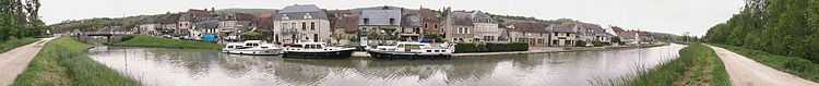
Panoramic view of Menetreol