Lyutibrod Rocks
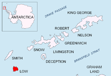
 Location of Low Island in the South Shetland Islands. | |
| Geography | |
|---|---|
| Location | Antarctica |
| Coordinates | 63°14′48″S 62°14′14″W / 63.24667°S 62.23722°W |
| Archipelago | South Shetland Islands |
| Country | |
| Demographics | |
| Population | 0 |
| Additional information | |
| Administered under the Antarctic Treaty System | |
Lyutibrod Rocks (Bulgarian: Лютибродски скали, ‘Lyutibrodski Skali’ \'lyu-ti-brod-ski ska-'li\) is the chain of rocks off the northwest coast of Low Island in the South Shetland Islands extending 860 m in east-west direction.
The feature is named after the settlement of Lyutibrod in Northwestern Bulgaria.
Location
The central and largest of Lyutibrod Rocks is located at 63°14′48″S 62°14′14″W / 63.24667°S 62.23722°W, which is 400 m west of Fernandez Point and 1.95 km north-northeast of Solnik Point.
Maps
- South Shetland Islands: Smith and Low Islands. Scale 1:150000 topographic map No. 13677. British Antarctic Survey, 2009.
- Antarctic Digital Database (ADD). Scale 1:250000 topographic map. Scientific Committee on Antarctic Research (SCAR), 1993-2012.
References
- Lyutibrod Rocks. SCAR Composite Antarctic Gazetteer.
- Bulgarian Antarctic Gazetteer. Antarctic Place-names Commission. (details in Bulgarian, basic data in English)
This article includes information from the Antarctic Place-names Commission of Bulgaria which is used with permission.