Lynn (MBTA station)
CENTRAL SQUARE - LYNN | |||||||||||
|---|---|---|---|---|---|---|---|---|---|---|---|
|
Lynn station on a rainy day in 2012 | |||||||||||
| Location |
325 Broad Street Lynn, MA, 01901-1511 | ||||||||||
| Coordinates | 42°27′46″N 70°56′45″W / 42.46280°N 70.94575°WCoordinates: 42°27′46″N 70°56′45″W / 42.46280°N 70.94575°W | ||||||||||
| Owned by | MBTA | ||||||||||
| Line(s) | |||||||||||
| Platforms | 1 island platform | ||||||||||
| Tracks | 2 | ||||||||||
| Connections | MBTA Bus: 426, 426W, 429, 431, 435, 436, 439, 441, 442, 455, 456, 459, | ||||||||||
| Construction | |||||||||||
| Parking | 965 spaces[1] | ||||||||||
| Bicycle facilities | 14 spaces | ||||||||||
| Disabled access | Yes | ||||||||||
| Other information | |||||||||||
| Fare zone | 2 | ||||||||||
| History | |||||||||||
| Opened | 1838 (first depot) | ||||||||||
| Rebuilt |
1848, 1872, 1895, 1952, January 21, 1992[2] | ||||||||||
| Previous names | Central Square | ||||||||||
| Traffic | |||||||||||
| Passengers (2013) | 662 (weekday inbound average)[3] | ||||||||||
| Services | |||||||||||
| |||||||||||
Lynn (signed as Central Square - Lynn) is a passenger rail station on the MBTA Commuter Rail Newburyport/Rockport Line in downtown Lynn, Massachusetts, located 11.5 route miles from North Station.[3] The station consists of a single center island platform serving the two station tracks on an elevated grade that runs through the downtown area of Lynn. A large parking garage is integrated into the station structure. The present station, built in 1992, is the latest in a series of depots built on approximately the same Central Square site since 1838. A number of other stations have also been located on several different rail lines in Lynn.
Lynn is also a major bus transfer point serving 12 MBTA Bus routes in the North Shore region, including routes leading to Salem, Marblehead, Wonderland, and the Liberty Tree Mall as well as downtown Boston.[1]
History
Early history
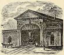
After the railroads from Boston to Lowell, Worcester, and Providence were chartered in 1830 and 1831, railroads to other surrounding cities including Newburyport and Portsmouth were proposed. Construction began in August 1836 but was slowed by the financial panic of 1837.[4] The Eastern Railroad built its line through Lynn at surface level, with operations starting on August 27, 1838 from Salem to East Boston via Lynn.[5] A number of stations have served Lynn, including a series of stations near the current location at Central Square as well as a number of other stations around the city.[6] The first depot at the Central Square location, built in 1838, was a small wooden building. It was replaced in 1848 with a brick building with a 2-track train shed.[6]
Lynn became the primary turnback point for the Saugus Branch Railroad when it opened in 1853, though a limited number of trains continued to Salem until World War I.[5] The first horsecars ran to Lynn in 1854 under the Lynn and Boston Street Railway.[7] Its line ran between its namesake cities; running through Charlestown on Chelsea Street, Chelsea and Revere on Broadway, then along the Salem Turnpike to Lynn.[8] On July 2, 1888, the Lynn & Boston became the first electrified trolley line in the Boston area.[9]
Great Lynn Depot War
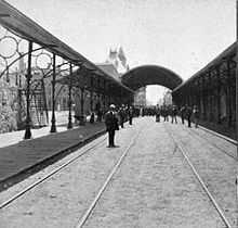
When the Eastern Railroad prepared to build a new depot in 1865, a great deal of controversy erupted – an event later known as the "Great Lynn Depot War". One faction wanted the replacement station built at the same Central Square location, while another wanted it built at Knight's Crossing, a block southwest at Market Street.[10] The Central Square faction was aided by a bill passed in the Massachusetts legislature on April 29, 1865, which disallowed a railroad from abandoning a station that had been in service more than five years, as well as an 1868 bill that specifically directed the Eastern Railroad to build the replacement station at Central Square.
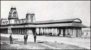
After a case which reached the Supreme Court in 1871 and a subsequent appeal to the United States Court, a decision was ultimately made to construct stations at both locations.[11] Both the Central Square and Market Street stations were in service by mid-1872, but it was untenable for the railroad to serve two stations just several hundred feet apart. The Market Street station was demolished in 1873 and replaced with a wooden shelter that served only a handful of trains.[11]
The depot controversy was a setback for the Eastern Railroad in a city where residents were already dissatisfied with poor service. In 1872, the Boston, Revere Beach & Lynn Railroad was charted as a direct competitor to the Eastern; service began from Market Street in 1875 and lasted until 1940.[12] Service to East Boston had been replaced with direct service to Boston via the Grand Junction Railroad in 1854, but Lynn - East Boston service was run from 1872 to 1880 to compete with the BRB&L. In 1880 the service was cut to a Revere - East Boston shuttle which lasted until 1905.[5]
From approximately the 1850s to the 1930s, Lynn was the terminus for some short turn Boston commuter trains. From 1881 to 1892, some of these trains ran via the Chelsea Beach Branch during the summer.[5]
Track elevation
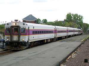
The 1872 Central Square station burned in 1889 and was replaced with a temporary station until a new depot with a 75-foot clock tower was built in 1895 on the north side of the tracks off Union Street. This station had two side platforms to serve the line's two tracks. As early as 1901, the city began planning to eliminate the numerous grade crossings in downtown Lynn. With 150 trains per day on the main line and 40 on the Saugus Branch, some streets were blocked for as long as half of daylight hours.[13] After legal issues, construction of an elevated viaduct began in September 1909. However, the New Haven Railroad briefly gained control of the Boston and Maine at this time, and intended to fully four-track the line through Lynn in conjunction with plans including a possible railroad tunnel under the harbor. The municipality initially intended to force the railroad to depress the four-track line below grade, but later reached an agreement with the railroad to modify the two-track viaduct for four tracks.[13]
The New Haven's plan to four-track the line as far as the branch line splits in Salem and Beverly was stymied by the costs to modify the grade crossings in Chelsea and the single-track tunnel at Salem. The only quadruple track to become operational was at Lynn station itself, with two island platforms to serve trains on all tracks.[13] The depot was modified "not for the better" in conjunction with the elevation project.[6] Many of the four-track bridge spans in Lynn, never used operationally, are still extant.[5]
B&M and MBTA eras
Streetcars service to Lynn continued under the Lynn & Boston until 1901 when it became part of the Boston & Northern Street Railway.[7] By the early 20th century, a number of lines crisscrossed Lynn, with a number of them serving the station.[14] The Bay State Street Railway took over operations in 1911 and joined the Eastern Massachusetts Street Railway in 1919. Trolley service in Lynn lasted until 1938.[7]
The Boston and Maine Railroad built a new, more modern station in 1952 but reused the 1914-built platforms. This single-story building, located on the south side of the tracks at Mt. Vernon and Exchange streets, was in the same flat-roofed brick style as Winchester Center and Wedgemere built five years later. The building was the first on the Boston & Maine system to have radiant heat, and also included a restaurant and newsstand. The 1895-built station was demolished to make room for a parking lot.[6] Saugus Branch service ended in May 1958, leaving through service on the Eastern Route as the only trains serving Lynn.[5] Around this time, the third and fourth tracks through the station were removed due to reduced traffic, leaving the station with effectively two side platforms serving two tracks.[15]
By the late 1980s, the nearly-40-year-old station and the older platforms were crumbling. Since the Newburyport/Rockport line was no longer a freight clearance route past the General Electric plant in West Lynn, a full-length high-level platform was selected. The wide platform occupies the width of one former island platform plus one track slot, with the line's two current tracks on each side. The 800-foot-long platform is located west of the older low platforms, which are still extant on the viaduct. A large parking garage and busway was built off Market Street; entrances to the platform are available from the garage and from Central Square.
An elevator is available to access the elevated platform from the ground level of the parking garage. This is one of a small number of elevators on the MBTA Commuter Rail system, and along with the pair at Framingham is one of the few on the system maintained by the MBTA rather than Amtrak, Massport, or local Regional Transportation Agencies.[16] In 2011, 20 security cameras were added to the station as a reaction to several assaults in the garage.[17]
Future
Lynn is intended to be the terminus of a future extension of the MBTA Blue Line, which would bring the line 4.5 additional miles from Wonderland in Revere to Lynn. This extension has been proposed in various forms for over 80 years. The 1926 Report on Improved Transportation Facilities and 1945–47 Coolidge Commission Report recommended that the East Boston Tunnel line, which had been converted to rapid transit from streetcars in 1924, be extended to Lynn via the Boston, Revere Beach & Lynn right-of-way.[18] Ever since the 1954 Revere extension was cut short to Wonderland, a further extension to Lynn has been planned. Following on the 1926 and 1945-47 studies, the 1966 Program for Mass Transportation recommended that the Blue Line be extended to Lynn, while the 1969 Recommended Highway and Transit Plan proposed that the extension run as far as Salem. An extension was not present in the 1972 Final Report of the Boston Transportation Planning Review, but the 1974 Transportation Plan revived the project with possible termini of Lynn, Salem, or even Route 128 in Peabody.[18] The 1978 Program for Mass Transportation report and 1983 Transportation Plan both continued support for an extension to Lynn.[18] Despite the continued recommendations, however, other projects like extensions of the Red and Orange lines were given funding instead of the Blue Line.
Despite numerous studies on the project and previous bond bills, there is currently no identified funding source; due to the MBTA's constrained finances, construction is not likely to begin soon. The 1992-built Lynn parking garage, designed for the capacity needed for the Blue Line extension, does not fill fully from commuter rail ridership.[6]
Other Lynn stations
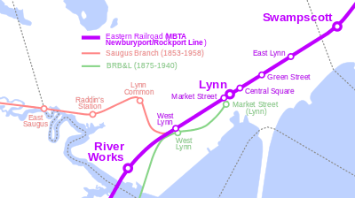
Lynn has also been home to eight other stations on different sites - none of which lasted into the MBTA era - plus a ninth that opened in 1965. Besides its downtown stops, the Eastern Railroad also served East Lynn from 1880 until Marblehead Branch service ended in June 1959. Stairways from the Chatham Street to the station site still exist, although no station building remains.[19] The 1896 depot was disassembled in 1912 in preparation for the downtown grade separation. It was moved to Durham, New Hampshire, where it now serves as the University of New Hampshire Dairy Bar and a station stop on Amtrak's Downeaster service. A West Lynn station was located at Commercial Street at the junction with the Saugus Branch Railroad, and Green Street was briefly located just east of Central Square.[4][20] Neither the West Lynn nor Green Street buildings survive.
The Boston, Revere Beach & Lynn also served its own Lynn depot (a block away from the Eastern Railroad station) at Market Street near Broad Street, as well its own West Lynn station adjacent to the Eastern Railroad station just east of Commercial Street.[20] Neither station is still extant.
Service on the Saugus Branch Railroad began from Boston to Lynn (via Malden) in 1853, serving Central Square and West Lynn plus three new stations in northwest Lynn. These included Lynn Common station at Western Avenue, Raddin's Station at Summer Street and Raddin Grove Avenue, and East Saugus at Lincoln Avenue on the Saugus/Lynn border.[20] Passenger service on the branch ended in May 1958; the branch is now abandoned and being turned into a rail trail.[4] None of the station buildings survive, though the surviving Cliftondale station in Saugus was identical to the East Saugus station.[6]
River Works station is located in West Lynn on the Newburyport/Rockport Line. Opened on September 9, 1965 as G.E. Works, it is for the sole use of GE Aviation employees.[2] Swampscott, located just outside Lynn in Swampscott, Massachusetts, also serves passengers from East Lynn.
Bus connections
Lynn serves as a major hub and transfer point for MBTA Bus routes serving the North Shore area. All routes pull into the station busway off Route 1A, though some can be caught at Central Square via the station's Exchange Street/Central Square entrance as well.
- 426 Central Square, Lynn - Haymarket Station via Cliftondale
- 426W Central Square, Lynn - Wonderland Station via Cliftondale Square (weekend version of 426)
- 429 Northgate Shopping Center - Central Square, Lynn via Linden Square & Square One Mall
- 431 Neptune Towers - Central Square, Lynn via Summer Street
- 435 Liberty Tree Mall - Central Square, Lynn via Peabody Square
- 436 Liberty Tree Mall - Central Square, Lynn via Goodwins Circle
- 439 Bass Point, Nahant - Wonderland via Central Square, Lynn
- 441 Marblehead - Wonderland via Central Square, Lynn, Paradise Road & Lynnway
- 442 Marblehead - Wonderland via Central Square, Lynn, Humphrey Street & Lynnway
- 455 Salem Depot - Wonderland via Central Square, Lynn
- 456 Salem Depot - Central Square, Lynn via Highland Avenue
- 459 Salem Depot - Downtown Crossing via Logan Airport & Central Square, Lynn
References
- ↑ 1.0 1.1 "Lynn". Massachusetts Bay Transportation Authority. Retrieved 13 March 2012.
- ↑ 2.0 2.1 Belcher, Jonathan (31 December 2011). "Changes to Transit Service in the MBTA district" (PDF). NETransit. Retrieved 13 March 2012.
- ↑ 3.0 3.1 "Ridership and Service Statistics" (PDF) (14 ed.). Massachusetts Bay Transportation Authority. 2014. Retrieved 30 July 2014.
- ↑ 4.0 4.1 4.2 Karr, Ronald Dale (1995). The Rail Lines of Southern New England. Branch Line Press. pp. 266–267. ISBN 0942147022.
- ↑ 5.0 5.1 5.2 5.3 5.4 5.5 Humphrey, Thomas J. and Clark, Norton D. (1985). Boston's Commuter Rail: The First 150 Years. Boston Street Railway Association. pp. 75–77. ISBN 9780685412947.
- ↑ 6.0 6.1 6.2 6.3 6.4 6.5 Roy, John H. Jr. (2007). A Field Guide to Southern New England Railroad Depots and Freight Houses. Branch Line Press. pp. 140, 184–186. ISBN 9780942147087.
- ↑ 7.0 7.1 7.2 Vandervoort, Bill. "Transit Systems in Massachusetts: Boston Area". Chicago Railfan. Retrieved 17 February 2013.
- ↑ Chase, J.G. (1865), Rail Road Map Showing the Street Rail Road Routes in and leading from Boston, with the Terminus of Each Road in Suburban Cities and Towns
- ↑ "Cambridge Led Off: Days Recalled When the City Government First Granted Permission for Electric Street Cars". Cambridge Tribune. 11 February 1905. Retrieved 3 November 2014.
- ↑ Allen, Charles (1871). Annual Report of the Attorney General for the Year ending December 31, 1870 (PDF). Wright and Potter. p. 12. Retrieved 20 March 2012.
- ↑ 11.0 11.1 Newhall, James R. (1897). HISTORY OF LYNN, ESSEX COUNTY, MASSACHUSETTS:INCLUDING Lynnfield, Saugus, Swampscott, and Nahant (PDF) 2. The Nichols Press. pp. 40–42. Retrieved 20 March 2012.
- ↑ Bradlee, Francis Boardman Crowninshield (1922). The Eastern railroad: a historical account of early railroading in eastern New England. The Essex Institute. p. 91. Retrieved 20 March 2012.
- ↑ 13.0 13.1 13.2 Breed, Charles B. (16 September 1915). "Track Elevation at Lynn, Mass.". Engineering News (Hill Publishing Co.) 74 (12): 533–537.
- ↑ "Lynn 1909 Plate 01". Atlas of Lynn, Swampscott and Saugus, 1905. L.J. Richards. 1909. Retrieved 17 February 2013.
- ↑ "Historic Aerials (aerial imagery of Lynn)". NETR Online. 1971. Retrieved 20 February 2013.
- ↑ TranSystems and Planners Collaborative (24 August 2007). "Evaluation of MBTA Paratransit and Accessible Fixed Route Transit Services: Final Report" (PDF). Massachusetts Bay Transportation Agency. p. 40. Retrieved 15 January 2013.
- ↑ "Improvements to Lynn Commuter Rail Station". Massachusetts Bay Transportation Authority. 2 June 2011. Retrieved 13 March 2012.
- ↑ 18.0 18.1 18.2 Central Transportation Planning Staff (15 November 1993). "The Transportation Plan for the Boston Region - Volume 2". National Transportation Library. Retrieved 3 July 2012.
- ↑ Chambers, Ted (27 September 2009). "Re-opening the East Lynn Commuter Rail Station". Lynn Happens. Retrieved 13 March 2012.
- ↑ 20.0 20.1 20.2 L.J. Richards (1905). "Lynn & Saugus & Swampscott 1905 Index Plate". Atlas of Lynn, Swampscott and Saugus, 1905. WardMaps LLC. Retrieved 26 October 2012.
External links
|