Lyaskovets Peak
| Lyaskovets Peak | |
|---|---|
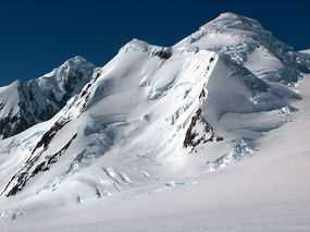
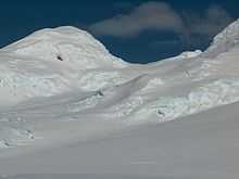
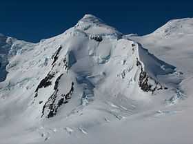 Lyaskovets Peak from Kuzman Knoll, with Shipka Saddle to the left, Catalunyan Saddle to the right, and Zograf Peak in the foreground. | |
| Elevation | 1,473 m (4,833 ft) |
| Prominence | 213 |
| Location | |
| Location | Livingston Island, Antarctica |
| Range | Tangra Mountains |
| Coordinates | 62°39′48.5″S 60°08′34.7″W / 62.663472°S 60.142972°WCoordinates: 62°39′48.5″S 60°08′34.7″W / 62.663472°S 60.142972°W |
| Climbing | |
| First ascent | 14 December 2004 Lyubomir Ivanov and Doychin Vasilev |
| Easiest route | snow/glacier |


Lyaskovets Peak (Vrah Lyaskovets \'vr&h 'lyas-ko-vets\) is the easternmost peak of Friesland Ridge in the Tangra Mountains, eastern Livingston Island and has an elevation 1,473 m. The peak is bounded by Catalunyan Saddle to the west and Shipka Saddle to the east and is heavily glaciated and crevassed, with precipitous western, southern and eastern slopes. It surmounts Huron Glacier to the northwest and northeast, and Macy Glacier and Brunow Bay area to the south. Its northern offshoot forms Zograf Peak, and is linked to Lozen Nunatak, Erma Knoll and Aheloy Nunatak in Huron Glacier.
The peak is named after Lyaskovets, a town in central northern Bulgaria.
Location
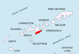
Lyaskovets Peak is located at 62°39′48.5″S 60°08′34.7″W / 62.663472°S 60.142972°W, which is 2.3 km east-northeast of Mount Friesland (the summit of Friesland Ridge and Livingston Island, 1,700 m), 3.2 km south-southeast of Kuzman Knoll, 1.33 km south by east of Zograf Peak, 1.3 km west of Levski Peak, and 4.6 km west by north of Great Needle Peak (the summit of Levski Ridge, approx. 1,690 m). The feature was mapped by the UK Directorate of Overseas Surveys in 1968, and by Bulgaria in 2005 and 2009.
History
The first ascent of Lyaskovets Peak was made on 14 December 2004 by Lyubomir Ivanov and Doychin Vasilev from Camp Academia (541 m) during the Tangra 2004/05 Survey. Their route (UIAA grade III) started with 4 km of solid but crevassed firn surface ascent up to Catalunyan Saddle (1,260 m) on the main crest of Tangra Mountains, from where they traversed the precipitous west slope of the peak until the north slope was reached, from where the summit – itself split by a crevasse – was easily reached.[1][2]
The second ascent, also by way of Ivanov–Vasilev route, was made by the Bulgarian mountaineers Doychin Boyanov and Nikolay Petkov on 1 January 2015.[3]
See also
Maps
- South Shetland Islands. Scale 1:200000 topographic map No. 3373. DOS 610 – W 62 58. Tolworth, UK, 1968.
- Islas Livingston y Decepción. Mapa topográfico a escala 1:100000. Madrid: Servicio Geográfico del Ejército, 1991.
- L.L. Ivanov et al, Antarctica: Livingston Island, South Shetland Islands (from English Strait to Morton Strait, with illustrations and ice-cover distribution), 1:100000 scale topographic map, Antarctic Place-names Commission of Bulgaria, Sofia, 2005
- L.L. Ivanov. Antarctica: Livingston Island and Greenwich, Robert, Snow and Smith Islands. Scale 1:120000 topographic map. Troyan: Manfred Wörner Foundation, 2010. ISBN 978-954-92032-9-5 (First edition 2009. ISBN 978-954-92032-6-4)
- Antarctic Digital Database (ADD). Scale 1:250000 topographic map of Antarctica. Scientific Committee on Antarctic Research (SCAR), 1993-2014.
Gallery
-
Lyaskovets Peak from the west extremity of Catalunyan Saddle with 'the Sphynx' in the foreground.
-
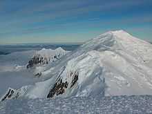
Lyaskovets Peak with Levski Peak on the left and Zograf Peak in the foreground.
-
On Lyaskovets Peak, looking east towards Levski Ridge.
-
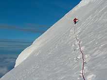
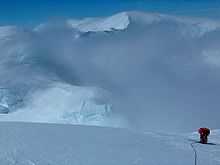
Traversing the west slope of Lyaskovets Peak back to Catalunyan Saddle during the first ascent of the peak.
-
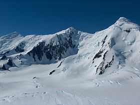
Central Tangra Mountains, left to right Great Needle Peak, Levski Peak and Lyaskovets Peak.
-
Lyaskovets Peak from Wörner Gap, with Catalunyan Saddle on the right.
-

Lyaskovets Peak from Bransfield Strait, with Shipka Saddle and Levski Peak on the right.
-
On the crest of Tangra Mountains, a view from Presian Ridge east towards Catalunyan Saddle (with the bivouac of Tangra 2004/05 Survey), Lyaskovets Peak is on the left, and St. Ivan Rilski Col and Great Needle Peak in the background.
References
- ↑ L.L. Ivanov, Livingston Island: Tangra Mountains, Komini Peak, west slope new rock route; Lyaskovets Peak, first ascent; Zograf Peak, first ascent; Vidin Heights, Melnik Peak, Melnik Ridge, first ascent, The American Alpine Journal, 2005, pp. 312-315.
- ↑ Livingston Island, Climb Magazine, Issue 14, Kettering, UK, April 2006, pp. 89-91.
- ↑ Doychin Boyanov and Nikolay Petkov on Lyaskovets Peak in Antarctica. 360° Magazine, 5 January 2015. ISSN 1313-9959 (in Bulharian)
External links
- Lyaskovets Peak. SCAR Composite Antarctic Gazetteer.
- Bulgarian Antarctic Gazetteer. Antarctic Place-names Commission. (details in Bulgarian, basic data in English)
This article includes information from the Antarctic Place-names Commission of Bulgaria which is used with permission.