Lusigny
| Lusigny | |
|---|---|
|
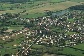
An aerial view of Lusigny | |
 Lusigny | |
|
Location within Auvergne region  Lusigny | |
| Coordinates: 46°35′19″N 3°29′32″E / 46.5886°N 3.4922°ECoordinates: 46°35′19″N 3°29′32″E / 46.5886°N 3.4922°E | |
| Country | France |
| Region | Auvergne |
| Department | Allier |
| Arrondissement | Moulins |
| Canton | Chevagnes |
| Intercommunality | Pays de Chevagnes en Sologne Bourbonnaise |
| Government | |
| • Mayor (2008–2014) | André Jardin |
| Area1 | 44.55 km2 (17.20 sq mi) |
| Population (2008)2 | 1,581 |
| • Density | 35/km2 (92/sq mi) |
| INSEE/Postal code | 03156 / 03230 |
| Elevation |
224–273 m (735–896 ft) (avg. 251 m or 823 ft) |
|
1 French Land Register data, which excludes lakes, ponds, glaciers > 1 km² (0.386 sq mi or 247 acres) and river estuaries. 2 Population without double counting: residents of multiple communes (e.g., students and military personnel) only counted once. | |
Lusigny is a commune in the Allier department in central France.
Geography
Lusigny is a town located in the Auvergne region, in the department of Allier. Lusigny is located in the canton of Chevagnes. It is located 12 km from the town of Moulins. Its inhabitants are known as the Lusignoises in French.
Population
| Historical population | ||
|---|---|---|
| Year | Pop. | ±% |
| 1962 | 1,058 | — |
| 1968 | 1,066 | +0.8% |
| 1975 | 1,295 | +21.5% |
| 1982 | 1,541 | +19.0% |
| 1990 | 1,575 | +2.2% |
| 1999 | 1,428 | −9.3% |
| 2008 | 1,581 | +10.7% |
See also
References
| Wikimedia Commons has media related to Lusigny. |