Lurcy-Lévis
| Lurcy-Lévis | ||
|---|---|---|
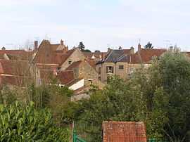
|
A general view of Lurcy-Lévis | ||
| ||
 Lurcy-Lévis | ||
|
Location within Auvergne region  Lurcy-Lévis | ||
| Coordinates: 46°43′50″N 2°56′21″E / 46.7306°N 2.9392°ECoordinates: 46°43′50″N 2°56′21″E / 46.7306°N 2.9392°E | ||
| Country | France | |
| Region | Auvergne | |
| Department | Allier | |
| Arrondissement | Moulins | |
| Canton | Lurcy-Lévis | |
| Intercommunality | Pays de Lévis en Bocage Bourbonnais | |
| Government | ||
| • Mayor (2008–2014) | Jacques Bourdier | |
| Area1 | 71.42 km2 (27.58 sq mi) | |
| Population (2008)2 | 2,139 | |
| • Density | 30/km2 (78/sq mi) | |
| INSEE/Postal code | 03155 / 03320 | |
| Elevation |
196–283 m (643–928 ft) (avg. 132 m or 433 ft) | |
|
1 French Land Register data, which excludes lakes, ponds, glaciers > 1 km² (0.386 sq mi or 247 acres) and river estuaries. 2 Population without double counting: residents of multiple communes (e.g., students and military personnel) only counted once. | ||

Lurcy-Lévis is a commune in the Allier department in Auvergne in central France.
It is around 38 km (24 mi) from the nearest large town (Moulins).
Population
| Historical population | ||
|---|---|---|
| Year | Pop. | ±% |
| 1962 | 2,400 | — |
| 1968 | 2,429 | +1.2% |
| 1975 | 2,292 | −5.6% |
| 1982 | 2,294 | +0.1% |
| 1990 | 2,080 | −9.3% |
| 1999 | 2,092 | +0.6% |
| 2008 | 2,139 | +2.2% |
Economy
Within Lurcy-Lévis, there is a small Atac supermarket, a tourist information centre and a few specialist shops.
Sport
Nearby there is also a motor racing test track able to accommodate F1 and F3 racing cars. The Grand Prix circuit of Magny Cours is only 30 km away.
See also
References
External links
| Wikimedia Commons has media related to Lurcy-Lévis. |