Luras
| Luras | |
|---|---|
| Comune | |
| Comune di Luras | |
|
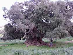
The millennial wild olive tree in Luras | |
 Luras Location of Luras in Italy | |
| Coordinates: 40°56′N 9°11′E / 40.933°N 9.183°ECoordinates: 40°56′N 9°11′E / 40.933°N 9.183°E | |
| Country | Italy |
| Region | Sardinia |
| Province | Province of Olbia-Tempio (OT) |
| Area | |
| • Total | 86.9 km2 (33.6 sq mi) |
| Elevation | 500 m (1,600 ft) |
| Population (Dec. 2004) | |
| • Total | 2,627 |
| • Density | 30/km2 (78/sq mi) |
| Demonym | Luresi |
| Time zone | CET (UTC+1) |
| • Summer (DST) | CEST (UTC+2) |
| Postal code | 07025 |
| Dialing code | 079 |
Luras (Sardinian: Lùras, Gallurese: Lùrisi) is a comune (municipality) in the Province of Olbia-Tempio in the Italian region Sardinia, located about 190 kilometres (120 mi) north of Cagliari and about 25 kilometres (16 mi) west of Olbia. As of 31 December 2004, it had a population of 2,627 and an area of 86.9 square kilometres (33.6 sq mi).[1]
Luras borders the following municipalities: Arzachena, Calangianus, Luogosanto, Sant'Antonio di Gallura, Tempio Pausania.
Demographic evolution

Celebrities
- Giacomo Pala, (Luras, 1849 – Rome, 1927) lawyer, member of the XX to XXIV legislature of the Kingdom of Italy
- Filippo Addis, (Luras, 1884 – Sassari, 1974), writer and literary critic
- Giorgio Bardanzellu (Luras, 1888 – Rome 1974), attorney and highly decorated officer in World War I; deputy in the XXIX legislature of the Kingdom of Italy and the republican II and III
- Giovanni Giua (Sassari, 1895 – Rome 1997), born and bred in Luras, engineer, colonel of artillery, a professor in the School Application and Institute of army soldiers. He participated in the taking of Gorizia, the Tenth Battle of the Isonzo (1917), the Battle of the Western Alps (1940) and was bureau chief command of the regiments of artillery attached to the Corps d 'Army of the Alps' Italian Army in Russia attorney and highly decorated officer in World War I; deputy in the XXIX legislature of the Kingdom of Italy and the republican II and III.(1942–43).
- Tonino Forteleoni (Luras, 1915–1996), cork sculptor
- Mariano Pintus (Luras, 1916 – Roma, 1983), journalist, a deputy from II to V republican legislature
- Giovanni Antonio Meloni (Luras, 1926–2001), physician and microbiologist.
- Giovanni Scanu, (Luras, 1907–2002), Sardinian Guitar player
- Mavie Bardanzellu, (Luras, 1938), theater and film actress
- Roberto Diana, (Luras, 1983), musician, composer and producer
References
| Wikimedia Commons has media related to Luras. |