Lupton, Cumbria
| Lupton | |
 Lupton |
|
 Lupton |
|
| Population | 165 (2001) |
|---|---|
| OS grid reference | SD5581 |
| Civil parish | Lupton |
| District | South Lakeland |
| Shire county | Cumbria |
| Region | North West |
| Country | England |
| Sovereign state | United Kingdom |
| Post town | CARNFORTH |
| Postcode district | LA6 |
| Dialling code | 01539 |
| Police | Cumbria |
| Fire | Cumbria |
| Ambulance | North West |
| EU Parliament | North West England |
| UK Parliament | Westmorland and Lonsdale |
Coordinates: 54°13′30″N 2°41′10″W / 54.225°N 2.686°W
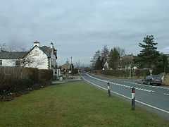
Lupton is a linear village and civil parish in the South Lakeland district of the English county of Cumbria. The village stretches along the main A65 road north west of Kirkby Lonsdale, and is located 2.3 miles (3.7 km) from the village of Hutton Roof. While not housing a large number of residents, Lupton is spread over a large land area, with many farms. The parish has a population of 165.[1]
All Saints Church, part of the Rainbow Parish has services every fortnight. Carol singers from the church visit village houses annually, and midnight mass is held on Christmas Eve. Lupton's public house, the Plough was recently refurbished by new owners. It is a popular dining location, and is in-keeping with the Lake District trend of such "gastropubs". Lupton Tower is an 18th-century house which is now used as a corporate training center.
References
- ↑ Office for National Statistics: Census 2001 : Parish Headcounts : South Lakeland Retrieved 26 October 2010
External links
| Wikimedia Commons has media related to Lupton, Cumbria. |
- Map sources for Lupton, Cumbria
| ||||||||||||||||||