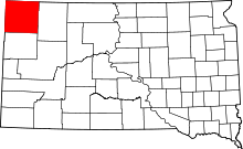
Ludlow, South Dakota
| Ludlow | |
|---|---|
| Unincorporated community | |
 Ludlow Location within the state of South Dakota | |
| Coordinates: 45°50′4″N 103°22′34″W / 45.83444°N 103.37611°WCoordinates: 45°50′4″N 103°22′34″W / 45.83444°N 103.37611°W | |
| Country | United States |
| State | South Dakota |
| County | Harding |
| Time zone | Central (CST) (UTC-6) |
| • Summer (DST) | CDT (UTC-5) |
| ZIP codes | 57755 |
Ludlow is an unincorporated rural hamlet in rural northern Harding County, South Dakota, United States. It is located on Federal Highway 85 about 12 miles north of Buffalo, the Harding County seat, and 6 miles south of the North Dakota border. Although not tracked by the Census Bureau, Ludlow has been assigned the ZIP code of 57755. It is primarily a service center for the rural area which it occupies, offering a public school for grades K-8 and a fire department. Additional businesses in the immediate vicinity include several large cattle ranches. Medical, legal, and grocery services are absent, the nearest being in Buffalo. The city boundaries are uncertain and these organizations are apparently, from satellite map views, widely scattered around the designated town location, which is usually pinpointed at an empty highway intersection. The Population of Ludlow is 3. Ludlow also has an annual lamb barbecue.
| |||||||||||||||||
