Luckett, Cornwall
Coordinates: 50°32′27″N 4°16′29″W / 50.5407°N 4.2746°W
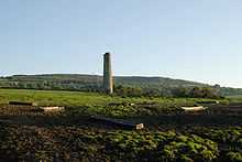
Mining landscape south from Luckett
Luckett is a hamlet in east Cornwall, England. It is situated in a former mining area beside the River Tamar approximately three miles (5 km) north of Callington.[1]
South of the hamlet is Greenscoombe Wood, Luckett SSSI (Site of Special Scientific Interest), noted for its biological interest.[2]
References
- ↑ Ordnance Survey: Landranger map sheet 201 Plymouth & Launceston ISBN 978-0-319-23146-3
- ↑ "Greenscoombe Wood, Luckett". Natural England. 1986. Retrieved 1 November 2011.
| ||||||||||||||||||||||||||