Lozère
| Lozère | ||
|---|---|---|
| Department | ||
|
Prefecture building of the Lozère department, in Mende | ||
| ||
 Location of Lozère in France | ||
| Coordinates: 44°20′N 3°36′E / 44.333°N 3.600°ECoordinates: 44°20′N 3°36′E / 44.333°N 3.600°E | ||
| Country | France | |
| Region | Languedoc-Roussillon | |
| Prefecture | Mende | |
| Subprefectures | Florac | |
| Government | ||
| • President of the General Council | Jean-Paul Pourquier | |
| Area1 | ||
| • Total | 5,167 km2 (1,995 sq mi) | |
| Population (1999) | ||
| • Total | 73,509 | |
| • Rank | 100th | |
| • Density | 14/km2 (37/sq mi) | |
| Time zone | CET (UTC+1) | |
| • Summer (DST) | CEST (UTC+2) | |
| Department number | 48 | |
| Arrondissements | 2 | |
| Cantons | 25 | |
| Communes | 185 | |
| ^1 French Land Register data, which exclude estuaries, and lakes, ponds, and glaciers larger than 1 km2 | ||


Lozère (French pronunciation: [lɔzɛʁ]; Occitan: Losera), is a department in southeast France near the Massif Central, named after Mont Lozère.
History
Lozère is one of the original 83 departments created during the French Revolution on March 4, 1790. It was created from part of the former province of Languedoc.
Pliny's Natural History praised the cheese of Lozère:
- The kinds of cheese that are most esteemed at Rome, where the various good things of all nations are to be judged of by comparison, are those that come from the provinces of Nemausus, and more especially the area[1] there of Lesura and Gabalis (Lozère and Gévaudan); but its excellence is only very short-lived, and it must be eaten while it is fresh.[2]
During the period 1764-67 the Beast of Gévaudan was a creature that terrorized the general area of the former province of Gévaudan, with nearly identical borders to today's Lozère, in the Margeride Mountains.
Geography
The geography of Lozère is complicated, covering four mountain ranges. In the north-west, the basalt plateau of Aubrac rises between 1,000 and 1,450m, with a cold humid climate influenced by the Atlantic. The north and north-east of the department contains the Margeride mountains, which are formed of granite, and have peaks between 1,000 and 1,550m. The climate here is also cold, but dryer than Aubrac, with less snow.
The Causses are a series of very dry limestone plateaus in the south-west, and the south-east contains the Cévennes, which include the highest point in the department, the granite Mont Lozère at 1,702m.
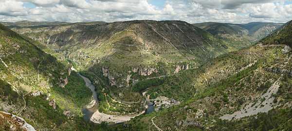
The department also contains numerous rivers, above and below ground, including the Tarn, whose source is on Mont Lozère, and which flows through the Gorges du Tarn in the Causses.
Administration and politics
Lozère is the northernmost part of the current Languedoc-Roussillon region and is surrounded by the departments of Cantal, Haute-Loire, Ardèche, Gard and Aveyron.
On the General Council of Lozère a majority is held by the right, with 16 councillors to the left's 9. The President of the Council is Jean-Paul Pourquier, who represents the canton of Massegros. Lozère elects one Deputy to the National Assembly and one Senator to the Palace of Luxembourg. The deputy, as of 2012, represents the Union for a Popular Movement (UMP) while the senator is an independent of the left.
Economy
The main activities are cattle farming and tourism. There is barely any agricultural farming in Lozère due to poor soil quality. The hardy Aubrac is the most commonly farmed cattle breed here.
The region has one of the lowest rates of unemployment in France, which may be attributed to the enforced long-standing tradition whereby young people emigrate to cities such as Lyon, Marseille, Montpellier when they reach working age.
Land use

Lozère has a surface area of 5,167 km2. It is a rural department, with relatively little land taken up by roads and buildings. Overall the land use is divided as follows:
- Forest 43.81%
- Heath & other open land 31.19%
- Arable land 12.74%
- Fields 11.36%
- Roads and buildings 0.54%
- Rivers and ponds 0.36%
Demographics
The inhabitants of the department are called Lozériens. Lozère is the least populated French department.
The low population density (14 inhabitant/km²) is thought to be due to the region's poor soils and to rural depopulation, which was particularly high in the region between 1850 and 1910.
In recent years, the department's population has increased slightly, as it is thought to offer a good quality of life, and due to improved transport networks. However, the population is older than the national average.
Tourism
Tourist activities include caving and a variety of sports, such as skiing and kayaking. Lozère contains a part of the Cévennes National Park. Lozère is considered one of the best areas in France for trout fishing. Rivers such as the Lot, Tarn and Truyère are particularly noted for their trout populations.
Notes
-

Church of Marvejols
-

Sainte-Enimie, one of the most beautiful villages of France
-

Cévennes National Park
-

Statue of the Beast of Gévaudan in Auvers

See also
- Cantons of the Lozère department
- Communes of the Lozère department
- Arrondissements of the Lozère department
External links
| Wikimedia Commons has media related to Category:Lozère. |
- (French) Prefecture website
- (French) Conseil Général website
- (English) Lozère on netrando.com