Lower Halstow
| Lower Halstow | |
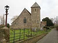 St Margaret's of Antioch, dates back to Saxon times |
|
 Lower Halstow |
|
| Population | 1,180 |
|---|---|
| District | Swale |
| Shire county | Kent |
| Region | South East |
| Country | England |
| Sovereign state | United Kingdom |
| Dialling code | 01795 |
| Police | Kent |
| Fire | Kent |
| Ambulance | South East Coast |
| EU Parliament | South East England |
Coordinates: 51°22′26″N 0°40′08″E / 51.3738°N 0.669°ELower Halstow is a village located in Kent, England. The village is situated on the banks of the Medway Estuary. It lies north of Newington on the A2 Roman road.
It has a long and interesting history, with evidence of constant occupation since the Iron Age. Being so close to the water, Lower Halstow has (until recently) been a village that has made its living from the water. Whether it be ancient pottery making, ancient fishing, barge building,[1] or in the 19th- and 20th-century brick-making (Eastwoods Brickworks),[2] the water has been the lifeblood of the village.
According to Edward Hasted in 1798, two large hospital ships, commonly called lazarettos, (which were the surviving hulks of forty-four gun ships) were moored in Halstow Creek. The lazarettos monitored ships coming to England which were forced to stay in the creek under quarantine, to protect the country from infectious diseases.[3]
In 1563, Queen Elizabeth ordered a survey, and Halstow Key (a wharf on the creek), was made up of 24 people in houses and 14 living on boats. There were two hamlets, one beside the wharf and the other around Halstow Green on Lower Street. The rest of the northern lands were salt marsh. Lands heading southwards (measuring 1200 acres) were heavy clay. All the lands were under the control of the manor of Milton Regis.[3]
In 2011, the population of the village was 1,180.[4]
Etymology
The name of the village has developed gradually over the years: Holy Place (Halig stow) Pronounced "ail-stoo", with a long "oo" as in "through" c. 1100; Halgastaw, 1160; Halgastow, 1199; Halegestowe,[3] 1226; Halgesto, 1576; Halstowe, 1610; Halstoe, c. 1790; Halstow, 1810 – Lower Halstow.
Church
On the banks of the Medway Estuary is the church of St Margaret's of Antioch. This Grade II listed church has a long history that can be traced back to Saxon times.[5] It is in the diocese of Canterbury, and deanery of Sittingbourne.[3] The first recorded parish priest was John de London who was a nephew to St Thomas Becket.[3]
The church has features and ancient artifacts that are still in use today. The church can trace its oldest parts back to the 7th century, making it one of the oldest churches still in use in England. Some points of interest are:
- Roman tiles built into the brickwork (taken from a Roman villa and temple in the village)
- A Saxon window built into the wall of the church
- An ancient Norman lead font – very rare and possibly the oldest in the country
- Medieval frescos and graffiti – a statement of what life was like in pre-reformation England
- A war memorial for the men of the village who died in the Great War
Other notes
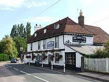
The village also has a Grade II listed public house, the Three Tuns Inn (early 18th century).[6] Also the Grade II listed Green Farm House.[7]
See also
- High Halstow on the Hoo Peninsula
References
- ↑ Robinson, Hayley (6 February 2014). "Westmoreland barge returns to Lower Halstow". kentonline.co.uk. Retrieved 19 March 2014.
- ↑ "A Barging Childhood". bbc.co.uk. 22 April 2008. Retrieved 21 March 2014.
- ↑ 3.0 3.1 3.2 3.3 3.4 Hasted, Edward (1799). "Parishes". The History and Topographical Survey of the County of Kent (Institute of Historical Research) 6: 34–40. Retrieved 28 February 2014.
- ↑ Ordinary Resident Population
- ↑ "Church of St Margaret of Antioch, Lower Halstow". www.britishlistedbuildings.co.uk. Retrieved 28 February 2014.
- ↑ "The Three Tuns Inn, Lower Halstow". www.britishlistedbuildings.co.uk. Retrieved 28 February 2014.
- ↑ "Green Farm House, Lower Halstow". www.britishlistedbuildings.co.uk. Retrieved 28 February 2014.
External links
![]() Media related to Lower Halstow at Wikimedia Commons
Media related to Lower Halstow at Wikimedia Commons