Louisiana State Route 64
| |
|---|---|
| Route information | |
| Length: | 35.00 mi (56.33 km) |
| Existed: | 1924 – 1955 |
| Major junctions | |
| South end: |
|
|
| |
| North end: |
|
| Highway system | |
| |
.svg.png)
Louisiana State Route 64 (LA 64) was one of the 98 original state highways that were established in 1924. It ran in a south to north direction for 35.00 miles (56.33 km), spanning from Columbia through an intersection with LA 15 to Rayville.
Route description
"Beginning at Columbia, to Woolen Lake, Douciere Store, Buckner, Charlieville, Red Mouth Bridge, Roger Baughton's Farm, Alto, O'Neil's Store to Rayville." - 1924 Louisiana Legislative Route Description
From the south, LA 64 began at an intersection with US 165/LA 14. LA 64 followed the Ouachita River for a distance before turning to the northeast, crossing Bayou Lafourche on a bridge that still is stamped with "State Route No. 64." LA 64 first crossed the Boeuf River on a ferry, but was later rerouted onto a steel truss bridge at Hebert.
After crossing the river, LA 64 followed the river north, meeting LA 15 in Alto and eventually truncating at an intersection with LA 47, two miles south of Rayville.
Gallery
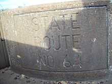 Bridge stamped with State Route 64 |
 Old steel truss bridge over the Boeuf River |
Major intersections
| Parish | Location | mi | km | Destinations | Notes |
|---|---|---|---|---|---|
| Caldwell | Columbia | 0.0 | 0.0 | Southern terminus | |
| Richland | Alto | 25.0 | 40.2 | Begin concurrency with LA 15 | |
| 25.6 | 41.2 | End concurrency with LA 15 | |||
| Rayville | 35.0 | 56.3 | Northern terminus | ||
| 1.000 mi = 1.609 km; 1.000 km = 0.621 mi | |||||