Louisiana Highway 96
| ||||
|---|---|---|---|---|
 | ||||
| Route information | ||||
| Maintained by Louisiana DOTD | ||||
| Length: | 19.5 mi[1] (31.4 km) | |||
| Major junctions | ||||
| West end: |
| |||
| East end: |
| |||
| Location | ||||
| Parishes: | Lafayette, St. Martin | |||
| Highway system | ||||
| ||||
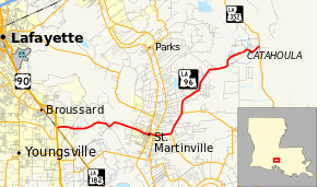
Louisiana Highway 96 (LA 96) is a 19.5-mile-long (31.4 km) state highway in Louisiana, extending from its western terminus of LA 182 near US 90 to the Bayou Benoit Levee (LA 352) near Catahoula Lake to the east.[1]
Major intersections
| Parish | Location | mi[1] | km | Destinations | Notes |
|---|---|---|---|---|---|
| Lafayette | Broussard | 0.0 | 0.0 | ||
| St. Martin | St. Martinville | 7.3 | 11.7 | Southern end of LA 31 overlap | |
| 7.5 | 12.1 | Northern end of LA 31 overlap | |||
| 7.8 | 12.6 | Western end of LA 347 overlap | |||
| 7.9 | 12.7 | Eastern end of LA 347 overlap | |||
| 9.1 | 14.6 | Northern terminus of LA 345 | |||
| 10.8 | 17.4 | Western terminus of LA 679 | |||
| 19.5 | 31.4 | ||||
| 1.000 mi = 1.609 km; 1.000 km = 0.621 mi | |||||
References
- ↑ 1.0 1.1 1.2 Google (May 31, 2012). "Louisiana Highway 96" (Map). Google Maps. Google. Retrieved May 31, 2012.
External links
Route map: Bing
