Louisiana Highway 75
| ||||
|---|---|---|---|---|
 | ||||
| Route information | ||||
| Maintained by Louisiana DOTD | ||||
| Length: | 47.1 mi[1] (75.8 km) | |||
| Major junctions | ||||
| West end: | Cul-de-sac near Pigeon | |||
| East end: |
| |||
| Location | ||||
| Parishes: | Iberville, Ascension | |||
| Highway system | ||||
| ||||

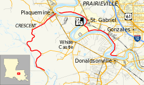
Louisiana Highway 75 (LA 75) is a state highway in Louisiana in two segments. The western segment of the highway begins at a dead end southeast of Pigeon, Iberville Parish and ends at the entrance to the Plaquemine Ferry in Plaquemine. After crossing the Mississippi River on the ferry, the road runs along the River's eastern bank to Carville, cuts across a peninsula, and ends at an intersection with LA 22/LA 942 in Darrow, Ascension Parish.[1]
References
- ↑ 1.0 1.1 Google (January 21, 2015). "Louisiana Highway 75" (Map). Google Maps. Google. Retrieved January 21, 2015.