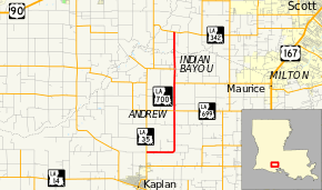
Louisiana Highway 700
| ||||
|---|---|---|---|---|
 | ||||
| Route information | ||||
| Maintained by Louisiana DOTD | ||||
| Length: | 10.7 mi[1] (17.2 km) | |||
| Major junctions | ||||
| South end: |
| |||
| North end: |
| |||
| Location | ||||
| Parishes: | Vermilion, Lafayette | |||
| Highway system | ||||
| ||||
Louisiana Highway 700 (LA 700) is a state highway that serves Vermilion and Lafayette parishes in the U.S. state of Louisiana. Its southern terminus is at LA 35 north of Kaplan and travels east for two miles (3.2 km) before heading north eventually intersecting LA 699. Afterwards, LA 92 briefly runs concurrent with LA 700. After entering Lafayette Parish, it ends at LA 342 southeast of Rayne, Louisiana.
Major junctions
| County | Location | mi[1] | km | Destinations | Notes |
|---|---|---|---|---|---|
| Vermilion | 0.0 | 0.0 | |||
| Andrew | 5.0 | 8.0 | |||
| 7.0 | 11.3 | Southern end of LA 92 concurrency | |||
| Indian Bayou | 8.0 | 12.9 | Northern end of LA 92 concurrency | ||
| Lafayette | 10.7 | 17.2 | |||
1.000 mi = 1.609 km; 1.000 km = 0.621 mi
| |||||
References
- ↑ 1.0 1.1 Google (February 27, 2015). "Louisiana Highway 700" (Map). Google Maps. Google. Retrieved February 27, 2015.
