Louisiana Highway 68
| ||||
|---|---|---|---|---|
 | ||||
| Route information | ||||
| Maintained by Louisiana DOTD | ||||
| Length: | 19.3 mi[1] (31.1 km) | |||
| Major junctions | ||||
| South end: |
| |||
| North end: |
| |||
| Location | ||||
| Parishes: | East Feliciana, East Baton Rouge | |||
| Highway system | ||||
| ||||
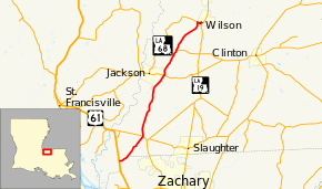
Louisiana Highway 68 (LA 68) is a 19.3-mile-long (31.1 km) state highway in Louisiana, extending from US 61 at the south end to LA 19 at the north end.[1] The route is mostly in East Feliciana Parish with a short segment near its southern terminus straddling the East Feliciana-East Baton Rouge parish line.
Major junctions
The entire highway is in East Feliciana Parish.
| Location | mi[1] | km | Destinations | Notes | |
|---|---|---|---|---|---|
| 0.0 | 0.0 | ||||
| 3.9 | 6.3 | ||||
| Jackson | 11.3 | 18.2 | |||
| 14.5 | 23.3 | Western terminus of LA 963 | |||
| Wilson | 18.6 | 29.9 | Northern terminus of LA 952 | ||
| 19.3 | 31.1 | ||||
| 1.000 mi = 1.609 km; 1.000 km = 0.621 mi | |||||
References
- ↑ 1.0 1.1 1.2 Google (May 31, 2012). "Louisiana Highway 68" (Map). Google Maps. Google. Retrieved May 31, 2012.
External links
Route map: Bing
