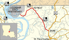
Louisiana Highway 66
| ||||
|---|---|---|---|---|
 | ||||
| Route information | ||||
| Maintained by Louisiana DOTD | ||||
| Length: | 19.6 mi[1] (31.5 km) | |||
| Major junctions | ||||
| West end: | Louisiana State Penitentiary entrance | |||
| East end: |
| |||
| Location | ||||
| Parishes: | West Feliciana | |||
| Highway system | ||||
| ||||
Louisiana Highway 66 (LA 66) is a state highway in West Feliciana Parish, Louisiana. LA 66 connects U.S. Route 61 with the Louisiana State Penitentiary (Angola).[1]
LA 66 is parallel to the old Tunica Trace. In 1988 the Louisiana Legislature passed Act 350, which designated Highway 66 as "Tunica Trace."[2]
Major intersections
The entire route is in West Feliciana Parish.
| Location | mi[1] | km | Destinations | Notes | |
|---|---|---|---|---|---|
| Angola | 0.0 | 0.0 | Entrance to Louisiana State Penitentiary | ||
| Retreat | 7.1 | 11.4 | Southern terminus of LA 969 | ||
| 11.7 | 18.8 | Eastern terminus of LA 968 | |||
| Bains | 19.6 | 31.5 | |||
| 1.000 mi = 1.609 km; 1.000 km = 0.621 mi | |||||
References
- ↑ 1.0 1.1 1.2 Google (January 14, 2015). "Louisiana Highway 66" (Map). Google Maps. Google. Retrieved January 14, 2015.
- ↑ "Retracing the Tunica Trace." The Advocate. August 7, 1988. Retrieved on September 28, 2010.
