Louisiana Highway 594
| ||||
|---|---|---|---|---|
 | ||||
| Route information | ||||
| Maintained by Louisiana DOTD | ||||
| Length: | 13.5 mi[1] (21.7 km) | |||
| Existed: | 1955 – present | |||
| Major junctions | ||||
| South end: |
| |||
|
| ||||
| North end: |
| |||
| Location | ||||
| Parishes: | Ouachita | |||
| Highway system | ||||
| ||||

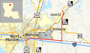
Louisiana Highway 594 (LA 594) is a state highway in Louisiana. It spans 13.5 miles (21.7 km), serving Ouachita Parish.
Route description
LA 594 begins at an intersection with LA 15 just south of LA 15's intersection with US 165 Business. LA 594 then crosses I-20 before meeting the North 18th Street extension, which connects I-20 with US 80.
Paralleling I-20, LA 594 passes under US 165 near the Pecanland Mall, continuing to the east for a few miles. LA 594 turns to the north at an exit with I-20; Russell Sage Wildlife Management Area is to the south of the Interstate. Passing Ouachita Parish High School, LA 594 meets US 80, continuing north to its terminus at LA 139, which continues in a northeastern direction to Bastrop.
LA 594 is a two-lane, undivided highway for its entire length, except for the intersection with I-20 at North 18th Street.
Junction list
The entire highway is in Ouachita Parish.
| Location | mi[1] | km | Destinations | Notes | |
|---|---|---|---|---|---|
| Monroe | 0.0 | 0.0 | |||
| 0.6– 0.9 | 1.0– 1.4 | Exit 117B (I-20) | |||
| 9.2 | 14.8 | ||||
| Swartz | 13.5 | 21.7 | |||
| 1.000 mi = 1.609 km; 1.000 km = 0.621 mi | |||||
See also
- Louisiana portal
- U.S. Roads portal
References
- ↑ 1.0 1.1 Google (February 21, 2015). "Louisiana Highway 594" (Map). Google Maps. Google. Retrieved February 21, 2015.
External links
Route map: Bing