Louisiana Highway 471
| ||||
|---|---|---|---|---|
 | ||||
| Route information | ||||
| Maintained by Louisiana DOTD | ||||
| Length: | 17.8 mi[1] (28.6 km) | |||
| Existed: | 1955 – present | |||
| Major junctions | ||||
| South end: |
| |||
|
| ||||
| North end: |
| |||
| Location | ||||
| Parishes: | Grant, Winn | |||
| Highway system | ||||
| ||||

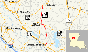
Louisiana Highway 471 (LA 471) is a state highway in Louisiana that serves Grant and Winn parishes. It spans 17.8 miles (28.6 km) in a south-to-north direction. The highway is also paired with LA 122 for a short distance.
Route description
From the south, LA 471 begins at an intersection with US 71 north of Colfax. It travels through timber lands and hills before meeting LA 122 south of Verda. LA 122 and LA 471 are paired together for the next mile, where LA 122 splits to the west, while LA 471 turns north. LA 471 then travels into Winn Parish before ending at an intersection with LA 34 south of Atlanta.
LA 471 is an undivided, two-lane highway for its entire length. Before the 1955 renumbering, LA 471 was State Route 5. The importance of State Route 5 was that it carried the original US 167 to its terminus at US 71, which is also LA 471's southern terminus. US 167 was later routed onto State Route 99, which it follows to this day.
Major intersections
| Parish | Location | mi[1] | km | Destinations | Notes |
|---|---|---|---|---|---|
| Grant | Summerfield | 0.0 | 0.0 | ||
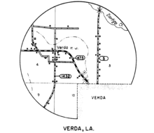
| Verda | 8.7 | 14.0 | Southern end of LA 122 concurrency | ||
| 10.0 | 16.1 | Northern end of LA 122 concurrency | |||
| Winn | 17.8 | 28.6 | |||
| 1.000 mi = 1.609 km; 1.000 km = 0.621 mi | |||||
See also
- Louisiana portal
- U.S. Roads portal
References
- ↑ 1.0 1.1 Google (February 10, 2015). "Louisiana Highway 471" (Map). Google Maps. Google. Retrieved February 10, 2015.