Louisiana Highway 43
| ||||
|---|---|---|---|---|
 | ||||
| Route information | ||||
| Maintained by Louisiana DOTD | ||||
| Length: | 44.4 mi[1] (71.5 km) | |||
| Major junctions | ||||
| South end: |
| |||
|
| ||||
| North end: |
| |||
| Location | ||||
| Parishes: | Livingston, St. Helena | |||
| Highway system | ||||
| ||||
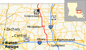
Louisiana Highway 43 (LA 43) is a 44.4-mile-long (71.5 km) north-south state highway in Louisiana, extending from LA 42, north to the Mississippi state line, continuing as Mississippi Highway 568.[1]
Route description
The highway begins at LA 42 near Springfield, and goes north intersecting with Interstate 12 at its exit 32. At Albany, it intersects with U.S. Route 190. As it enters St. Helena Parish, it intersects LA 441 and LA 16 near Montpelier. LA 42 and LA 16 form a concurrency and head into Montpelier. After the highways split, LA 42 continues in a northerly direction, intersects with LA 1045, and when it enters Greensburg it intersects with LA 10 and continues north, intersects with Louisiana Highway 38, and exits Louisiana as Mississippi Highway 568 into Amite County, Mississippi.
References
- ↑ 1.0 1.1 Google (January 4, 2015). "Louisiana Highway 43" (Map). Google Maps. Google. Retrieved January 4, 2015.
