Louisiana Highway 422
| ||||
|---|---|---|---|---|
 | ||||
| Route information | ||||
| Maintained by Louisiana DOTD | ||||
| Length: | 12.1 mi[1] (19.5 km) | |||
| Major junctions | ||||
| West end: |
| |||
| East end: |
| |||
| Location | ||||
| Parishes: | East Feliciana | |||
| Highway system | ||||
| ||||

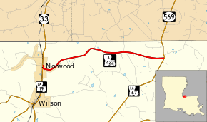
Louisiana Highway 422 (LA 422) is a state highway in Louisiana that serves East Feliciana Parish. It runs 12.1 miles (19.5 km) in a west to east direction. It is known briefly in Norwood as Azalea Street.
Route description
From the west, LA 422 begins at an intersection with LA 19 in Norwood and heads eastward. It runs through the north-central portion of the parish, just south of the state line. LA 422 ends at an intersection with LA 67 north of Clinton.
It is an undivided, two-lane highway for its entire length.
Major junctions
The entire highway is in East Feliciana Parish.
| Location | mi[1] | km | Destinations | Notes | |
|---|---|---|---|---|---|
| Norwood | 0.0 | 0.0 | |||
| 12.1 | 19.5 | ||||
| 1.000 mi = 1.609 km; 1.000 km = 0.621 mi | |||||
References
- ↑ 1.0 1.1 Google (February 15, 2015). "Louisiana Highway 422" (Map). Google Maps. Google. Retrieved February 15, 2015.
External links
Route map: Bing