Louisiana Highway 413
| ||||
|---|---|---|---|---|
 | ||||
| Route information | ||||
| Maintained by Louisiana DOTD | ||||
| Length: | 23.8 mi[1] (38.3 km) | |||
| Existed: | 1955 renumbering – present | |||
| Major junctions | ||||
| South end: |
| |||
|
| ||||
| North end: |
| |||
| Location | ||||
| Parishes: | West Baton Rouge, Pointe Coupee | |||
| Highway system | ||||
| ||||

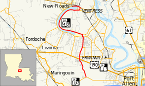
Louisiana Highway 413 (LA 413) is a state highway in Louisiana. It runs 23.8 miles (38.3 km) in a north–south direction from LA 76 northeast of Rosedale to LA 1 Business in New Roads.
Route description
LA 413 begins at an intersection with LA 76 in West Baton Rouge Parish, and heads due north approximately 4.3 miles (6.9 km) towards Erwinville. This stretch of LA 413 is locally known as Poydras Bayou Road. In Erwinville, LA 413 intersects U.S. Route 190 and LA 1 near milepost 4.3 (kilometer marker 6.9). It then proceeds north approximately 0.4 miles (0.64 km) to an intersection with LA 620 near milepost 4.7 (kilometer marker 7.6). The highway at this point is locally referred to still as Poydras Bayou Road, but also as "Snake Road" due to its sharp curves that follow Bayou Poydras. It continues north approximately 1.8 miles (2.9 km) and crosses into Pointe Coupee Parish near the intersection of LA 3091 at milepost 6.8 (kilometer marker 10.9).
LA 413 continues north into Pointe Coupee to an intersection with LA 416. It turns left and proceeds west, where it shares LA 416's roadbed for approximately 0.1 miles (0.16 km), then turns right, (known locally as Zach Road at this point) proceeding north to an intersection with LA 414. LA 413 turns left and proceeds west through Jarreau, then north through Dupont, and then east to another intersection with LA 414 in Ventress. LA 413 then turns right and proceeds to an intersection with LA 415 in Ventress. The highway then turns left and proceeds west until it ends at milepost 23.8 (kilometer marker 38.3), inside the city limits of New Roads.
Speed Limit:
55 mph (90 km/h) Beginning of highway at LA-76 to Erwinville
45 mph (70 km/h) south side of Erwinville to north side of US-190 intersection
35 mph (55 km/h) north side of US-190 intersection to LA-620
45 mph (70 km/h) north side of LA-620 to end of the highway in New Roads, LA
Major intersections
| Parish | Location | mi[1] | km | Destinations | Notes |
|---|---|---|---|---|---|
| West Baton Rouge | 0.0 | 0.0 | |||
| Erwinville | 4.3 | 6.9 | |||
| 4.7 | 7.6 | Western terminus of LA 620 | |||
| 6.8 | 10.9 | Northern terminus of LA 3091 | |||
| Pointe Coupee | Lakeland | 9.1 | 14.6 | South end of LA 416 concurrency | |
| 9.3 | 15.0 | North end of LA 416 concurrency | |||
| 9.8 | 15.8 | Southern terminus of LA 414 | |||
| Ventress | 21.5 | 34.6 | Northern terminus of LA 414 | ||
| Patin | 22.1 | 35.6 | Northern terminus of LA 415 | ||
| New Roads | 23.8 | 38.3 | |||
1.000 mi = 1.609 km; 1.000 km = 0.621 mi
| |||||
References
- ↑ 1.0 1.1 Google (February 8, 2015). "Louisiana Highway 413" (Map). Google Maps. Google. Retrieved February 8, 2015.