Louisiana Highway 3121
| ||||
|---|---|---|---|---|
 | ||||
| Route information | ||||
| Maintained by Louisiana DOTD | ||||
| Length: | 6.1 mi[1] (9.8 km) | |||
| Major junctions | ||||
| South end: |
| |||
| North end: |
| |||
| Highway system | ||||
| ||||

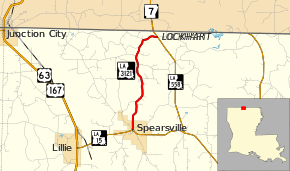
Louisiana Highway 3121 (LA 3121) is a state highway in Louisiana that serves Union Parish. It spans 6.1 miles (9.8 km).
Route description
LA 3121 begins at an intersection with LA 15 in the small town of Spearsville, then travels north through forested areas. It turns northeast before meeting LA 558 less than a mile from the Louisiana-Arkansas state line.
LA 3121 is an undivided, two-lane road for its entire route.
Junction list
The entire highway is in Union Parish.
| Location | mi[1] | km | Destinations | Notes | |
|---|---|---|---|---|---|
| Spearsville | 0.0 | 0.0 | |||
| 0.1 | 0.2 | Western terminus of LA 3121 Spur | |||
| Lockhart | 6.1 | 9.8 | |||
| 1.000 mi = 1.609 km; 1.000 km = 0.621 mi | |||||
Spur route
| |
|---|---|
| Location: | Spearsville |
| Length: | 0.13 mi (0.21 km) |
Louisiana Spur Highway 3121 (LA 3121 Spur) is a 0.13-mile-long (0.21 km) highway in Spearsville that serves the purpose of a city route. It serves Spearsville High School, owned and operated by the Union Parish School District.
- Junction list
The entire highway is in Spearsville, Union Parish.
| mi | km | Destinations | Notes | ||
|---|---|---|---|---|---|
| 0.0 | 0.0 | ||||
| 0.1 | 0.2 | Spearsville High School | |||
| 1.000 mi = 1.609 km; 1.000 km = 0.621 mi | |||||
References
- ↑ 1.0 1.1 Google (February 14, 2015). "Louisiana Highway 3121" (Map). Google Maps. Google. Retrieved February 14, 2015.
External links
Route map: Bing