Louisiana Highway 301
| ||||
|---|---|---|---|---|
| Barataria Boulevard | ||||
 | ||||
| Route information | ||||
| Maintained by Louisiana DOTD | ||||
| Length: | 3.0 mi[1] (4.8 km) | |||
| Existed: | 1955 renumbering – present | |||
| Major junctions | ||||
| South end: | Dead end at Bayou Villars/Gulf Intracoastal Waterway near Jean Lafitte | |||
| North end: |
| |||
| Location | ||||
| Parishes: | Jefferson | |||
| Highway system | ||||
| ||||
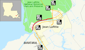
Louisiana Highway 301 (LA 301) is a north–south state highway in Louisiana that serves Jefferson Parish. It spans 3.0 miles (4.8 km) in a west to east direction[1] and is known locally as Barataria Boulevard.
Route description
From the west, LA 301 begins at the north bank of Bayou Villars. A portion of LA 301 south of the bayou is now designated as LA 3257, although it is unclear whether both sections were ever connected. It runs in an easterly direction along the north bank of Bayou Barataria to a terminus with LA 45 near Crown Point. With the truncation of LA 301 at its current terminus, the highway runs more west to east than south to north, but because of its former length, it maintains a north/south banner.
LA 301 is an undivided, two-lane road for its entire length.
Major intersections
The entire highway is in Jefferson Parish.
| Location | mi[1] | km | Destinations | Notes | |
|---|---|---|---|---|---|
| 0.0 | 0.0 | Dead end at Bayou Villars/Gulf Intracoastal Waterway | Southern terminus | ||
| Crown Point | 3.0 | 4.8 | Northern terminus | ||
| 1.000 mi = 1.609 km; 1.000 km = 0.621 mi | |||||
References
External links
Route map: Bing
