Louisiana Highway 30
Louisiana Highway 30 (LA 30) is a state highway in Louisiana that serves East Baton Rouge, Iberville, and Ascension Parishes. It spans 28.1 miles (45.2 km) in roughly a southeast/northwest direction.
Route description
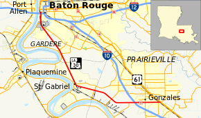
From the southeast, LA 30 begins at an intersection with US 61 and LA 431 halfway between Gonzales and Sorrento. LA 30 then runs due west, intersecting LA 44 and I-10 in Gonzales. It passes the Tanger Factory Mall at its intersection with Interstate 10. LA 30 then turns northwestward and crosses LA 73. While passing various chemical enterprises, the highway enters Iberville Parish before crossing LA 74 at St. Gabriel. The highway then enters East Baton Rouge Parish and eventually the city of Baton Rouge proper, at which time it becomes Nicholson Drive. After passing LA 42 and LSU, it widens to four lanes and turns northward. In its final stretch, it moves into downtown Baton Rouge and crosses Interstate 10 one last time and ends at LA 73 (Government Street).
History
From 1955 until the 1960s, LA-30 took a much different route past LSU and ended at LA 22 near Darrow. At the southern end of LSU's campus, LA-30 followed present-day Nicholson Extension to then-LA-42 (Highland Road). The highway followed Highland until Gardere Lane (present-day LA-327 Spur). LA-30 went down Gardere to River Road where it followed the Mississippi River from south East Baton Rouge Parish to Ascension Parish. In the 1960s, the road took its present routing when Nicholson was extended from LSU to Gonzales.
Major intersections
References
External links
Template:Attached_KML/Louisiana Highway 30
|
|---|
| | Interstates | |
|---|
| | U.S. Highways | |
|---|
| | State Highways | |
|---|
| | Other | |
|---|
|