Louisiana Highway 17
| ||||
|---|---|---|---|---|
 | ||||
| Route information | ||||
| Maintained by Louisiana DOTD | ||||
| Length: | 66.8 mi[1] (107.5 km) | |||
| Existed: | 1955 – present | |||
| Major junctions | ||||
| South end: |
| |||
|
| ||||
| North end: |
| |||
| Location | ||||
| Parishes: | Franklin, Richland, West Carroll | |||
| Highway system | ||||
| ||||
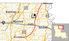
Louisiana Highway (LA 17) is a state highway that serves Franklin Parish, Richland Parish, and West Carroll Parish. It runs from north to south for 66.8 miles (107.5 km).
Route description
From the south, LA 17 begins at a junction with U.S. Route 425, LA 4, and LA 15 in Winnsboro and heads north-northeast through Franklin Parish. For the highway's first 1.7 miles (2.7 km), LA 17 is concurrent with LA 4. LA 17 then intersects Interstate 20 and passes through Delhi, where LA 17 also intersects U.S. Highway 80. LA 17 then continues northward into West Carroll Parish, where it intersects LA 134 in Epps. LA 17 also passes through Pioneer and Forest, Oak Grove, and Kilbourne. LA 17 then becomes Highway 159 at the Louisiana/Arkansas state line.
References
- ↑ Google (December 20, 2014). "Louisiana Highway 17" (Map). Google Maps. Google. Retrieved December 20, 2014.
