Louisiana Highway 15
| ||||
|---|---|---|---|---|
|
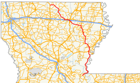
Route of LA 15 highlighted in red | ||||
| Route information | ||||
| Maintained by Louisiana DOTD | ||||
| Length: | 194.52 mi (313.05 km) | |||
| Existed: | 1924 – present | |||
| Major junctions | ||||
| South end: |
| |||
|
| ||||
| North end: |
| |||
| Highway system | ||||
| ||||
Louisiana Highway 15 (LA 15) is a state highway in Louisiana. It spans 194.52 miles (313.05 km), serving northeastern Louisiana, providing direct access to US 84 and Baton Rouge.
Route description
LA 15 begins as an exit from U.S. Route 167 just south of Lillie and heads due east towards Spearsville. From Spearsville, LA 15 turns to the southeast and shortly merges with LA 2 and LA 33 in Farmerville. LA 15 then turns southeastward again, leaves Union Parish, and enters Ouachita Parish. LA 15 then heads due south and merges with U.S. Route 80. U.S. 80/LA 15 then turns east through Claiborne, West Monroe and turns southeast and intersects with Interstate 20, southwest of downtown Monroe. It then meets US 165 before meeting LA 831, also known as Prairie Road.
LA 15 continues east-southeast through Ouachita Parish and passes through rural Richland Parish, where LA 15 crosses the Boeuf River on a historic truss bridge, dating from 1939. It then turns due south and is joined by U.S. Route 425 near Archibald, in a concurrence which continues to Ferriday.[1]
On the way to Ferriday, while in Franklin Parish, LA 15 passes through Baskin, Winnsboro, Gilbert, and Wisner. LA 15 then enters Catahoula Parish, where it passes through the town of Sicily Island and serves as the eastern terminus for LA 8. LA 15 turns east and enters Concordia Parish through Clayton, crossing the Tensas River. LA 15 intersects U.S. Route 65 just south of Clayton before splitting from U.S. 425 at Ferriday.
South of Ferriday, LA 15 runs parallel to the Mississippi River through Concordia Parish and Pointe Coupee Parish, passing through the Old River Control Structure, then ending at a three-way intersection with LA 1 and LA 970 in the town of Lettsworth.
LA 15 is a mix of two-lane, four-lane, and five-lane roads for its length. Before the 1955 Louisiana Highway renumbering, LA 15 was signed as State Route 15, having been spared in the renumbering.
Gallery
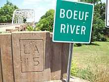 Bridge over the Boeuf River on LA 15 |
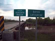 Ouachita/Richland Parish Line over Bayou Lafourche |
 Historical marker for General Claire Chennault in Gibson |
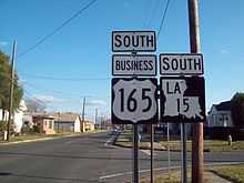 Signs along LA 15 in Monroe, LA |
Junction List
| Parish | Location | mi | km | Destinations | Notes |
|---|---|---|---|---|---|
| Pointe Coupee | Lettsworth | 0.0 | 0.0 | Southern terminus | |
| 2.7 | 4.3 | End of LA 970 concurrency | |||
| 4.9 | 7.9 | ||||
| West Feliciana | 6.0 | 9.7 | Old River Control Structure | ||
| Concordia | 24.7 | 39.8 | Original southern terminus of LA 15 | ||
| 42.3 | 68.1 | ||||
| 51.2 | 82.4 | ||||
| Ferriday | 58.1 | 93.5 | |||
| 59.2 | 95.3 | Begin concurrency with US 84 | |||
| 59.7 | 96.1 | End concurrency with US 84, begin concur. with US 425 | |||
| 60.1 | 96.7 | ||||
| Clayton | 65.8 | 105.9 | Southern terminus of US 65 | ||
| 66.3 | 106.7 | ||||
| Catahoula | 69.6 | 112.0 | |||
| 74.3 | 119.6 | ||||
| Sicily Island | 78.6 | 126.5 | |||
| 83.9 | 135.0 | ||||
| 85.7 | 137.9 | ||||
| Franklin | Wisner | 88.0 | 141.6 | Begin concurrency with LA 562 | |
| 88.3 | 142.1 | End concurrency with LA 562 | |||
| 89.3 | 143.7 | ||||
| Gilbert | 92.6 | 149.0 | Begin concurrency with LA 128 | ||
| 92.8 | 149.3 | ||||
| 93.2 | 150.0 | End concurrency with LA 128 | |||
| Chase | 96.4 | 155.1 | Old LA 15 | ||
| 98.1 | 157.9 | Old LA 15 | |||
| Winnsboro | 101.0 | 162.5 | |||
| 101.8 | 163.8 | ||||
| 102.1 | 164.3 | Begin concurrency with LA 865 | |||
| 102.3 | 164.6 | End concurrency with LA 865 | |||
| 102.9 | 165.6 | Begin concurrency with LA 4 | |||
| 103.3 | 166.2 | End concurrency with LA 4 | |||
| 105.1 | 169.1 | ||||
| 107.1 | 172.4 | ||||
| 108.5 | 174.6 | ||||
| Baskin | 109.6 | 176.4 | |||
| Richland | Mangham | 113.4 | 182.5 | Begin concurrency with LA 132 | |
| 114.5 | 184.3 | End concurrency with LA 132 | |||
| Archibald | 116.2 | 187.0 | |||
| 116.8 | 188.0 | End concurrency with US 425 | |||
| Alto | 121.2 | 195.1 | Begin concurrency with LA 135 | ||
| 122.0 | 196.3 | End concurrency with LA 135 | |||
| 124.1 | 199.7 | ||||
| Ouachita | 135.2 | 217.6 | |||
| Monroe | 138.4 | 222.7 | |||
| 140.5 | 226.1 | ||||
| 140.7 | 226.4 | Begin concurrency with US 165 Business | |||
| 141.2 | 227.2 | ||||
| 141.7 | 228.0 | End concurrency with US 165 BUS, begin concur. with US 80 | |||
| West Monroe | 142.6 | 229.5 | |||
| 144.4 | 232.4 | ||||
| 144.9 | 233.2 | Begin concurrency with LA 617 | |||
| 145.1 | 233.5 | End concurrency with LA 617 | |||
| Cheniere | 148.1 | 238.3 | End concurrency with US 80 | ||
| Drew | 152.5 | 245.4 | |||
| Union | 157.4 | 253.3 | |||
| 163.8 | 263.6 | ||||
| 164.1 | 264.1 | ||||
| 170.6 | 274.6 | Begin concurrency with LA 33 | |||
| Farmerville | 173.1 | 278.6 | |||
| 173.4 | 279.1 | Begin concurrency with LA 2 | |||
| 174.1 | 280.2 | End concurrency with LA 33 | |||
| 174.3 | 280.5 | End concurrency with LA 2 | |||
| 176.4 | 283.9 | ||||
| 185.2 | 298.1 | ||||
| 188.2 | 302.9 | ||||
| Spearsville | 191.8 | 308.7 | |||
| Lillie | 194.5 | 313.0 | Northern terminus | ||
1.000 mi = 1.609 km; 1.000 km = 0.621 mi
| |||||
References
- ↑ See US 425 for its creation as an afterthought in the federal system and for its anomalous number.