Louisiana Highway 14
| ||||
|---|---|---|---|---|
 | ||||
| Route information | ||||
| Maintained by Louisiana DOTD | ||||
| Length: | 100.44 mi (161.64 km) | |||
| Existed: | 1955 renumbering – present | |||
| Major junctions | ||||
| West end: |
| |||
|
| ||||
| East end: |
| |||
| Location | ||||
| Parishes: | Calcasieu, Jefferson Davis, Vermillion, Iberia | |||
| Highway system | ||||
| ||||

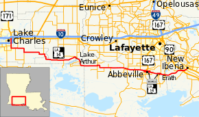
Louisiana Highway 14 (LA 14) is a state highway that serves Calcasieu Parish, Jefferson Davis Parish, Vermillion Parish, and Iberia Parish in Louisiana. It spans 100 miles (160 km), running from west to east.[1] LA 14 is often referred to as "The Four Lane" by the local residents.
Route description
From the west, LA 14 begins at a junction with U.S. Route 90 and US 171 in Lake Charles and heads due south, intersecting Interstate 210 before leaving the city limits. LA 14 then turns due east after intersecting LA 27. LA 14 intersects LA 26 in Lake Arthur, LA 91 in Gueydan, LA 13 and LA 35 in Kaplan, and U.S. Route 167 and LA 82 north of Abbeville. Louisiana Highway 14 Business runs through downtown Abbeville while the Bypass runs just north of downtown. The two highways split west of the city limits and rejoin just east of the city limits. LA 14 then splits Erath with Louisiana Highway 14 Business running through Erath and the Bypass running just north of the city. The two roads join each other just before Delcambre before entering Iberia Parish. There, LA 14 turns to the northeast and intersects with US 90 outside of New Iberia. LA 14 then ends in downtown New Iberia at the intersection of LA 14 and Louisiana Highway 182.[1]
References
- ↑ 1.0 1.1 Google (December 13, 2014). "Louisiana Highway 14" (Map). Google Maps. Google. Retrieved December 13, 2014.