Louisiana Highway 12
| ||||
|---|---|---|---|---|
 | ||||
| Route information | ||||
| Maintained by Louisiana DOTD | ||||
| Length: | 34.58 mi[1] (55.65 km) | |||
| Existed: | 1955 renumbering – present | |||
| Major junctions | ||||
| West end: |
| |||
|
| ||||
| East end: |
| |||
| Highway system | ||||
| ||||

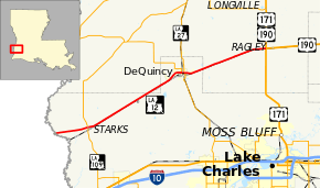
Louisiana Highway 12 (LA 12) is a state highway that serves Calcasieu Parish and Beauregard Parish in southwestern Louisiana. It spans 34.58 miles (55.65 km) from its western terminus at the Texas state line (where it becomes State Highway 12 on the opposite bank of the Sabine River) to its eastern terminus at an interchange with U.S. Route 171 and U.S. Route 190 in Beauregard Parish.
Route description
Texas State Highway 12, which was renumbered from the prior Texas State Highway 235 in 1959 to provide seamless numbering with LA 12, crosses the Sabine River from Texas. LA 12 heads due east and intersects LA 109 in Starks. Past Starks, LA 12 turns to the northeast and heads toward DeQuincy alongside a rail line. In the center of the city, LA 12 meets (and briefly overlaps) LA 27. Outside of DeQuincy, LA 12 continues on a northeasterly track to Ragley, where it terminates at an interchange with U.S. Route 171 and U.S. Route 190. Here, US 190 enters from the north concurrent with US 171 and exits to follow the right-of-way of LA 12 east while US 171 continues southward past LA 12.
LA 12 was part of a route once known as the Evangeline Highway which ran from Beaumont, Texas, to Baton Rouge. The Evangeline Highway (also known as the Acadiana Trail) comprises Interstate 10/U.S. Route 90, Texas State Highway 12, Louisiana Highway 12, and U.S. Route 190.
Major intersections
| Parish | Location | mi | km | Destinations | Notes |
|---|---|---|---|---|---|
| Calcasieu | Texas state line (Deweyville Swing Bridge over Sabine River) | ||||
| Starks | |||||
| DeQuincy | |||||
| West end of LA 27 overlap | |||||
| East end of LA 27 overlap | |||||
| Beauregard | Ragley | Interchange | |||
1.000 mi = 1.609 km; 1.000 km = 0.621 mi
| |||||
References
- ↑ Google (November 20, 2012). "Louisiana Highway 12" (Map). Google Maps. Google. Retrieved November 20, 2012.
External links
Route map: Bing