Louisiana Highway 111
| ||||
|---|---|---|---|---|
 | ||||
| Route information | ||||
| Maintained by Louisiana DOTD | ||||
| Length: | 45.8 mi[1] (73.7 km) | |||
| Existed: | 1955 renumbering – present | |||
| Major junctions | ||||
| South end: |
| |||
|
| ||||
| East end: |
| |||
| Location | ||||
| Parishes: | Beauregard, Vernon | |||
| Highway system | ||||
| ||||
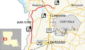
Louisiana Highway 111 (LA 111) is a state highway in Louisiana. It spans 45.8 miles (73.7 km) and runs from south to north though its northernmost 19-mile-long (31 km) segment runs east-west. LA 111 is a mostly rural two lane highway. The southern terminus is at an intersection with U.S. Route 190 (US 190) in the unincorporated community of Junction and its northern terminus at an intersection with LA 117. The north-south portion of the highway skirts the Texas border and forms a loop around the city of Leesville.
Route description
LA 111 begins at a Y-intersection with US 190 in Junction, an unincorporated community in northern Beauregard Parish. It travels north and crosses the Bayou Anacoco into Vernon Parish. Just north of the crossing, LA 111 curves to the left and intersects LA 464 at its southern terminus. Throughout most of its north-south segment, LA 111 passes through forested areas, portions of which are a part of the Clear Creek Wildlife Management Area. In the middle of the forest, the highway passes through the community of Evans. LA 111 continues north before reaching LA 8 in Burr Ferry. LA 8 and LA 111 form a brief concurrency through Burr Ferry. LA 111 continues north, running parallel with the Sabine River, and intersects and merges with LA 392 east. LA 392 heads west from here and crosses into Texas over the Sabine River across the Toledo Bend Dam. LA 392 east splits running north while LA 111 continues east, crosses over the northern part of Vernon Lake, and enters Anacoco, intersecting with US 171. Continuing east LA 111 ends at the eastern terminus at LA 117 about five miles (8.0 km) north of Leesville.[1]
History
LA 111 is an old historic trail/road that among other things ran between two Ferries in Vernon Parish. Burr's Ferry in the south and one at a crossing near Toledo Bend in the north, was in an area that some considered the heart of the Neutral Strip (Louisiana), long before the Louisiana Purchase and even after the Adams-Onís Treaty. After the purchase and up until the first bridges these crossings were two of only four passages from Texas into Louisiana and LA 111 was an important road. For many years, until railroads were built, these were main trails for cattle entering Louisiana heading east to Alexandria, then New Orleans and farther points east.
Major junctions
| Parish | Location | mi[1] | km | Destinations | Notes |
|---|---|---|---|---|---|
| Beauregard | Junction | 0.0 | 0.0 | ||
| Vernon | 3.0 | 4.8 | Southern terminus of LA 464 | ||
| Burr Ferry | 16.4 | 26.4 | Southern end of LA 8 concurrency | ||
| 16.9 | 27.2 | Northern end of LA 8 concurrency | |||
| 26.3 | 42.3 | Southern end of LA 392 concurrency | |||
| 31.4 | 50.5 | Northern end of LA 392 concurrency | |||
| Anacoco | 37.0 | 59.5 | |||
| 45.8 | 73.7 | ||||
1.000 mi = 1.609 km; 1.000 km = 0.621 mi
| |||||
References
- ↑ 1.0 1.1 1.2 Google (January 27, 2015). "Louisiana Highway 111" (Map). Google Maps. Google. Retrieved January 27, 2015.
